Discover World-Leading Unmanned and Autonomous Technologies
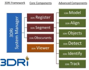
Discover cutting-edge solutions from leading global suppliers Neptec Technologies Corp. has further enhanced its 3DRi™ (3D Real-time intelligence™) software development kit (SDK). The 3DRi SDK, which is used together with Neptec’s real-time obscurant-penetrating 3D OPAL LiDAR sensors to easily develop intelligent 3D automation applications in harsh environments, is a library of proprietary software algorithms that extract actionable information from 3D sensors in real-time. The 3DRi SDK consists of the 3DRi System Manager/API and 3DRi Viewer, together with optional 3DRi Plugins that add out-of-the-box features such as object segmentation, recognition, tracking, automatic change detection and automatic scan alignment.
Enhancements included in the latest release of the 3DRi System Manager/API and 3DRi Viewer include Automatic Scan Scheduling, a Web-Engine and a Grid Generator that down-samples 3D data into a user-defined regularly spaced grid. Further improvements have also been made to the advanced 3DRi Plugins for real-time object recognition, object tracking, automatic scan alignment and DTM generation.
 “Real-time 3D applications are about the information contained in the 3D data, not the huge amounts of data being generated by today’s LiDAR scanners,” said Mike Sekerka, CEO of Neptec Technologies. “Unlike conventional approaches to mapping and monitoring, where millions of data points are captured and then painfully post-processed back at the office, we focus on real-time intelligent processing of our OPAL data to extract the valuable information right at the point of collection. It’s about ‘more information, less data!’ The Schedule and Grid Generator features make it easy to schedule data collection events and immediately reduce the amount of data being retained before it is handed off for further 3DRi processing.”
Neptec Technologies has been using its 3DRi SDK to create applications as diverse as automated volume reporting and mobile mapping to complex operator-assist solutions like haul truck spotting and collision avoidance beside excavators in open-pit mines.
“3DRi is the real differentiator when it comes to creating intelligent productivity solutions for industries like mining,” said Dr. Jon Peck, President and CEO of Peck Tech Consulting Ltd. “In today’s productivity environment, nobody has the time or the staff to post-process and manage huge amounts of 3D data. It’s all about getting the answers quickly and focusing on running an efficient and safe mining operation. 3DRi enables this.”
The 3DRi System Manager/API and Viewer are available free with Neptec’s OPAL 2.0 LiDAR sensors. Users can subscribe to additional features such as obscurants, segmentation, object recognition or tracking by licencing optional 3DRi Plugins. For complex real-time applications, Neptec provides 3DRi application development services to its clients.