MQ-4C Triton UAS Flies With New Search Radar

By Caroline Rees / 21 Apr 2015

Smart Sourcing for Unmanned Systems

Discover cutting-edge solutions from leading global suppliers
SUPPLIER SPOTLIGHT
Follow UST
MQ-4C Triton UAS

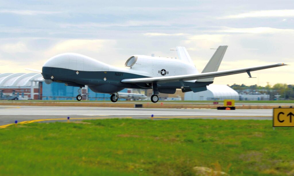
The MQ-4C Triton unmanned aircraft began sensor testing on April 18 and flew with its new maritime search radar. (U.S. Navy photo)

The Navy’s MQ-4C Triton UAS equipped with a new search radar completed its inaugural flight April 18 over Patuxent River air space.

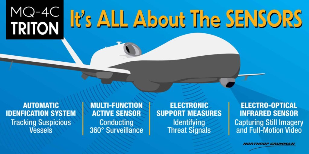
The radar, known as the Multi-Function Active Sensor (MFAS), is expected to greatly enhance maritime domain awareness by providing the MQ-4C with a 360-degree view of a large geographic area while providing all-weather coverage to expedite detecting, classifying, tracking and identifying points of interest.

“This first sensor flight is a huge achievement for the program,” said Sean Burke, Triton program manager. “Our Navy and Northrop Grumman team has worked extremely hard on this developmental effort, completing more than 40 surrogate flights over the last three years, and we saw the realization of that development work.”

During this initial test event, MFAS exercised its primary operating mode, known as Maritime Surface Surveillance (MSS). The MSS mode provides continuous watch over a broad area.

Watch the video:

“Our primary objective was to test this new radar, but we also looked at how the aircraft performed as well as testing additional data links,” said Lt. Cmdr. Glenn Rioux, government flight test director and senior Air Test and Evaluation Squadron (VX) 20 representative supporting the Triton integrated test team. “This was a successful flight on many levels. We are still reviewing the data and actively planning our next text event.”

Along with the MFAS radar, the MQ-4C will also carry an Electro-Optical/Infrared (EO/IR) sensor that will provide still imagery and full-motion video of potential threats; an electronic support measures package to identify and geolocate radar threat signals; and an Automatic Identification System (AIS) that will detect and track vessels equipped with AIS responders.

Triton UAS Infographic

When operational, the MQ-4C Triton UAS will provide 24/7 ISR coverage virtually anywhere in the world. Its ability to dwell at high altitudes will improve intelligence collection and bring an unprecedented level of maritime domain awareness to the warfighter operating and sustaining up to five orbits across the globe.

Posted by Caroline Rees Caroline co-founded Unmanned Systems Technology and has been at the forefront of the business ever since. With a Masters Degree in marketing Caroline has her finger on the pulse of all things unmanned and is committed to showcasing the very latest in unmanned technical innovation. Connect & Contact

Latest Articles

BotBlox Unveils Compact Solution for 1000BASE-T to 1000BASE-T1 Conversion

BotBlox has unveiled the SPEBlox Module, a compact and efficient solution for converting between standard gigabit Ethernet (1000BASE-T) and gigabit Single Pair Ethernet (1000BASE-T1).

Apr 30, 2025
Embention Strengthens Cybersecurity Frameworks for Aviation Technology

Embention discusses its approach to a structured cybersecurity framework built around ISO 27001 certification, strict internal policies, and secure protocols for safety-critical environments

Apr 30, 2025
Cambridge Pixel Enhances Offshore Monitoring with Advanced Tracking Systems

Cambridge Pixel has partnered with Elcome (India) to deliver radar-based technology supporting the security and monitoring of offshore platforms operated by Reliance Industries

Apr 30, 2025
Collaborative Robots Powering Scalable Automation

Explore how Elite Robots’ cobots are transforming manufacturing by enhancing safety, improving efficiency, and enabling seamless collaboration between humans and machines

Apr 30, 2025
Visualizing Coastal Flood Risks with Global Mapper

Discover how Global Mapper® is being used to model rising tides and predict flood risks in coastal cities like Portland, Maine

Apr 30, 2025
Spexi + LayerDrone: A New Era of Aerial Intelligence

Imagine a real-time, crowd-sourced map of Earth. Spexi, powered by LayerDrone, pays drone pilots to capture ultra-detailed imagery, offering organizations data that’s faster, cheaper, and more precise than traditional methods

Apr 29, 2025

Featured Content

Spexi + LayerDrone: A New Era of Aerial Intelligence

Imagine a real-time, crowd-sourced map of Earth. Spexi, powered by LayerDrone, pays drone pilots to capture ultra-detailed imagery, offering organizations data that’s faster, cheaper, and more precise than traditional methods

Apr 29, 2025
Apollo & Moonrock Launch $122.5m Drone, eVTOL Insurance Facility

Apollo and Moonrock take the lead on new $122.5m drone, eVTOL and aviation innovation insurance facility

Apr 22, 2025
ParaZero Unveils Advanced Parachute Recovery System

ParaZero launches the SafeAir M4, an advanced parachute recovery system designed for the DJI Matrice 4, enhancing drone safety, compliance, and mission readiness

Apr 17, 2025
Advancing Unmanned Systems Through Strategic Collaboration UST works with major OEMs to foster collaboration and increase engagement with SMEs, to accelerate innovation and drive unmanned systems capabilities forward.