


Discover World-Leading Unmanned and Autonomous Technologies
Discover cutting-edge solutions from leading global suppliers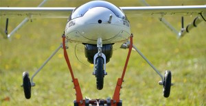 ING Robotic Aviation, a Canadian provider of robotic aircraft sensing solutions, has announced the launch of the next version of its Serenity fixed wing robotic aircraft system equipped with a wide area rapid mapping capability.
Serenity 1.1, an extended range and long endurance platform, has many advanced features. The main update is the addition of a customized commercial mapping payload. Using a 36 Megapixel aerial imager the Serenity can now perform 2D and 3D aerial mapping. Unlike any other fixed wing technology, this system has the capability to map vast amounts of land in a single 8 hour flight.
“This is an excellent capability for our customers,” states Ian Glenn, CEO of ING Robotic Aviation. “I am very pleased with the hard work our technology team has put in to make this a reality.”
Some of the other features of the system include a new tracking antenna system and a customized ground control station.


