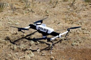
Ventura County Public Safety Agencies to Evaluate Aerovironment Qube UAV

By Caroline Rees / 29 Mar 2013

Smart Sourcing for Unmanned Systems

Discover cutting-edge solutions from leading global suppliers
SUPPLIER SPOTLIGHT
Follow UST
Aerovironment Qube UAV

Aerovironment Qube UAV

The Ventura County Sheriff’s Office has applied for a Certificate of Authorization (COA) through the Federal Aviation Administration (FAA) to allow training flights of an Unmanned Aerial Vehicle.

The COA will only allow limited operation within a restricted unpopulated area for training and evaluation purposes only. The evaluations will take place in conjunction with Sheriff’s Search and Rescue, the Ventura County Fire Department, and other public safety agencies.

The initial training flights will occur in the area of the Ventura River as well as portions of the Ventura County backcountry. Since the application has not yet been approved, actual flights may still be several months away.

The ultimate goal is to use the small UAV for critical life-saving efforts, such as locating missing persons and monitoring incidents where a hazardous condition exists.

The UAV being tested is the Aerovironment Qube, which is a VTOL UAV operating four small rotors that allow it to take off vertically. It is battery powered and remote controlled. It can stay aloft for a maximum of 40 minutes on a single charge. The Qube has a built-in camera system, but is otherwise incapable of carrying any payload.

Currently, the Sheriff’s Office utilizes four Bell Huey helicopters for a variety of public safety purposes. One of the primary missions of our air unit is search and rescue. While the UAV will not replace the Aviation Unit, there are many circumstances that do not require a fully equipped helicopter. It is hoped that a UAV will assist with lifesaving operations at a significantly reduced cost to the taxpayer.

UAVs also have a critical use in the fire service for mapping and aerial observation during wildland and other fires.

In addition to the FAA guidelines, which restrict flights to 400 feet above ground level and below, the Sheriff’s Office has developed its own policy to govern the use of the UAV for search and rescue purposes only. The FAA guidelines and the Sheriff’s Office policy are available to the public.

The request to the FAA is for training purposes only to review if the UAV has a useful and practical application in Ventura County.

Posted by Caroline Rees Caroline co-founded Unmanned Systems Technology and has been at the forefront of the business ever since. With a Masters Degree in marketing Caroline has her finger on the pulse of all things unmanned and is committed to showcasing the very latest in unmanned technical innovation. Connect & Contact

Latest Articles

Cellen Expands UAV Mission Capabilities with Hydrogen Fuel Cell Technology

Cellen outlines how its H2‑6 hydrogen-powered drone delivers long-endurance flight and zero-emission performance, overcoming battery limitations and enabling reliable, low-impact operations in sensitive or remote environments

Jul 15, 2025
Tulip Tech Extends Autonomous Drone Missions with Lithium Metal Technology

Tulip Tech and Tective have partnered to extend the ReFly drone’s range and endurance using advanced Lithium Metal battery technology

Jul 15, 2025
UAV Navigation to Supply Flight Control System for Fixed-Wing UAV Platform

UAV Navigation collaborates with SE Aviation to provide the DRIADE UAV with a VECTOR-600 flight control system enabling autonomous reconnaissance and wildfire response missions

Jul 15, 2025
AlarisPro Empowers UAS Operators to Meet Federal Mandates with Safety & Compliance Tools

AlarisPro describes how their Fleet Management Platform is positioned to help UAS operators prepare for BVLOS certifications under the new Executive Order

Jul 15, 2025
Police Department Utilizes Drones to Map Crash & Crime Scenes

Discover how Windham Police use drones and Blue Marble Geographics’ GIS tools to enhance crash investigations, speed up processing, and improve scene accuracy

Jul 15, 2025
SPECTRUM300 Mission-Ready Imaging for Small UAV Platforms

Explore Blitz Technology SPECTRUM300, a 330g dual-sensor gimbal delivering full HD EO and thermal imaging, built for lightweight UAVs and demanding ISR missions

Jul 15, 2025

Featured Content

SBG Systems Evaluates INS Performance in GNSS-Denied Marine Applications

SBG Systems evaluates the performance of its INS solutions in GNSS-denied marine environments, comparing system accuracy with and without DVL and warm-up support

Jul 14, 2025
USAF Uses Inertial Labs Drone Lidar for Tree Obstruction Survey

The US Air Force successfully used Inertial Labs drone Lidar and cloud software to quickly map tree obstructions at Joint Base Lewis-McChord (JBLM), improving airfield safety

Jul 11, 2025
New UAV to Combine Solar Hydrogen & Battery Power for Extended Flight

XSun and H3 Dynamics are developing the first UAV powered by solar, hydrogen, and batteries, aiming to deliver zero-emission, long-endurance unmanned flight

Jul 07, 2025
Advancing Unmanned Systems Through Strategic Collaboration UST works with major OEMs to foster collaboration and increase engagement with SMEs, to accelerate innovation and drive unmanned systems capabilities forward.