MicroPilot has completed work to integrate an OxTS xNAV miniature GNSS/INS system in to their UAV autopilots. The interface will allow MicroPilot systems to use the blended GNSS/IMU output of the inertial navigation system (INS) in their flight control system, providing accurate positioning.
Iain Clarke, Product Manager from OxTS says: “We were excited to work together with MicroPilot to develop an interface between our systems. As the UAV market continues to grow people are still discovering ways to take advantage of the platform. We hope this development brings new opportunities to customers looking for integrated systems and UAV navigation options.”
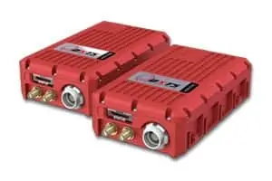 The xNAV is a miniature GNSS/INS system designed for commercial UAV mapping applications that require precise georeferencing capabilities. For UAV based LiDAR, hyperspectral or thermal mapping, a survey-grade INS is crucial to providing the accurate trajectory information needed when creating 3D pointclouds, digital terrain models, and other maps. Even photogrammetry applications can be enhanced with an INS, reducing the need for ground control points (GCP), lowering image processing time and removing jumps and gaps in data, saving time from reprocessing to fix errors.
While many autopilot systems have integrated GNSS, they are usually lower-grade, single frequency receivers only capable of 1-2 m accuracy. By developing an interface with OxTS systems, MicroPilot autopilots can use the centimetre-level RTK position output of the INS in their flight control system. As well as allowing more precise control and positioning, the autopilot receives the benefit of INS navigation which is robust and protected against GNSS dropouts. Thanks to the integrated GNSS and IMU in the xNAV, as well as OxTS’ tight-coupling technology, the navigation solution is smooth, resistant to GNSS jumps, and position drift is limited even when fewer than 4 satellites are in view. This can allow UASs to fly and navigate confidently in harsher GNSS environments such as urban canyons, near vegetation, or under bridges.
“MicroPilot is pleased to work with OxTS.” Says Howard Loewen, President of MicroPilot. “This integration will create a better performing system for our customers.”