


Discover World-Leading Unmanned and Autonomous Technologies
Discover cutting-edge solutions from leading global suppliers
LiDAR technology is widely recognized for its ability to generate precise topographic data, yet a common misconception persists: that LiDAR systems can “see through” physical obstacles like buildings or dense vegetation. Read more >>
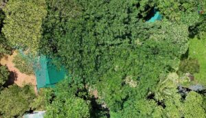
While this is not the case, the TersusMVP 400 showcases how LiDAR can excel in environments where traditional methods struggle, particularly in mapping through dense foliage and challenging terrains.
The Tersus MVP 400 leverages several advanced features that enhance its ability to provide reliable, accurate data even in obstructed landscapes. These features enable the system to capture ground-level information in areas with dense forest canopies, vegetation, and other obstacles where other LiDAR systems may struggle.
MVP 400 point clould.
At the core of the MVP 400’s capabilities is its use of a 1550nm near-infrared laser wavelength. This specific wavelength significantly reduces light scattering, making it particularly effective in conditions like light rain or fog, which typically hinder the performance of standard LiDAR systems. By minimizing scattering, the MVP 400 is able to maintain high accuracy and consistency in environments where visibility is compromised, allowing for better performance in vegetation mapping and terrain modeling.
Another key factor in the MVP 400’s performance is its pulse rate. The system is capable of emitting up to 1,000,000 laser pulses per second (1000 kHz PRF). This high pulse rate enables the system to continuously probe the environment, providing multiple opportunities to detect gaps in the vegetation. These constant pulses ensure that the MVP 400 can effectively capture data even in areas where traditional LiDAR systems might miss key information due to dense foliage.

Ground point to TIN.
In addition to its high pulse rate, the MVP 400’s multi-return capability stands out. The system can capture up to seven distinct echo returns from a single laser pulse, which is particularly valuable in environments with dense vegetation. This allows the system to gather comprehensive data about the vertical structure of objects like trees and accurately identify ground points, even through heavy canopy coverage. The ability to register multiple echo returns provides a clearer, more reliable picture of the environment than systems that capture fewer echoes.
By combining the 1550nm wavelength, high pulse rate, and multi-return functionality, the Tersus MVP 400 is able to provide superior data in difficult environments. The system’s ability to capture ground-level information through dense vegetation makes it an ideal solution for applications such as terrain modeling, environmental monitoring, and vegetation analysis.
In summary, while the Tersus MVP 400 cannot penetrate solid structures like buildings, its advanced features enable it to deliver high-precision data in environments where traditional LiDAR systems would typically struggle. With its high pulse rate, multiple echo returns, and effective wavelength, the MVP 400 provides accurate and reliable data, even in the most challenging, vegetated landscapes.
Read the original article >>


