Sentient Vision Develops Detection & Tracking Software for UAVs

By Mike Ball / 09 Jul 2021

Radar Processing Software

Discover cutting-edge solutions from 5 leading global suppliers
SUPPLIER SPOTLIGHT
Kestrel small object detection
Follow UST

Sentient Vision Systems, a leading developer of computer vision and artificial intelligence (AI) software solutions, has partnered with Unmanned Systems Technology (“UST”) to demonstrate their expertise in this field. The ‘Gold’ profile highlights how their imagery analysis systems provide autonomous real-time object detection and tracking capabilities for UAVs (unmanned aerial vehicles).

Kestrel moving object trackingKestrel Land provides high-precision automated real-time moving object detection for UAV EO/IR platforms. The open architecture system is sensor- and datalink-agnostic and can easily interface with almost any commercially available drone cameras.

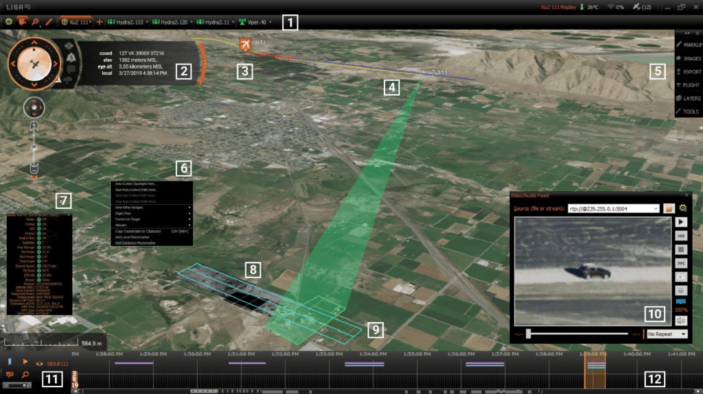
The AI-enabled software performs full motion video processing, continually examining over 60 factors frame-by-frame to detect moving objects such as humans or vehicles that may be too small for a human operator to pick up or are on the periphery of the scene. The software clearly marks targets of interest and can track full movement history as well as provide predicted future paths.

Kestrel Maritime surveillance systemKestrel Maritime provides automated moving object detection for wide-area maritime surveillance in conditions up to Sea State 6. It allows operators of UAV electro-optical or infrared sensors to track targets in full-motion video as small as a couple of pixels square that would otherwise be lost in darkness, haze or breaking waves.

With the ability to detect small wooden or fibreglass vessels, people, debris, fishing buoys and fast boats, Kestrel Maritime allows operators to determine the geolocation, size, speed and direction of a target and its movement history in real time. The specialized Search & Rescue (SAR) mode focuses on detecting up-turned hulls of small boats as well as life-saving equipment such as lifejackets and life rafts, resulting in much quicker time to rescue.

Night ViDAR real time object detection
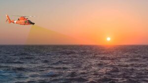
ViDAR (Visual Detection and Ranging) Maritime is a wide-area optical search system that uses computer vision and deep learning to autonomously find objects on the surface of the ocean in conditions up to Sea State 6. Featuring an external camera layout tailored to the specific drone platform and use case, and onboard low-SWaP processing electronics, it provides more than 300 times the coverage of existing EO/IR systems.

ViDAR Maritime provides operators with thumbnail images and coordinates of each object detected in real time. Upon selection of an image, it initiates automatic cross-cueing of the UAV’s primary sensor to objects of interest for closer inspection. The versatile system features specialized configuration profiles for search & rescue and wide area search, and can be tailored towards a variety of fixed-wing and rotary drone platforms.

ViDAR VMS PodsThe VMS-5 ViDAR Pod provides an easy way to deploy and integrate ViDAR Optical Radar capabilities onto fixed-wing or rotary UAVs for search and rescue or surveillance operations. The low-SWaP system features an array of multi-camera EO and Long Wave IR sensors to provide 180-degree search coverage in front or the aircraft, supporting both daytime and night-time operations.

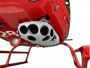
The VMS-5 ViDAR Pod is compatible with COTS mounting systems and wing strut mounts, and we can also provide bespoke mounting solutions for specific drone platforms.

Posted by Mike Ball Mike Ball is our resident technical editor here at Unmanned Systems Technology. Combining his passion for teaching, advanced engineering and all things unmanned, Mike keeps a watchful eye over everything related to the unmanned technical sector. With over 10 years’ experience in the unmanned field and a degree in engineering, Mike’s been heading up our technical team here for the last 8 years. Connect & Contact

Latest Articles

ARK FPV Flight Controller Now Supports Betaflight

The ARK FPV Flight Controller, a leading flight control solution for FPV drones, now officially supports Betaflight firmware

Feb 06, 2025
Aurora’s Energy Lab Pushing Limits of Battery & Fuel Cell Tech

Explore how Aurora Flight Science's advanced energy lab is enhancing battery efficiency, extending flight endurance, and revolutionizing fuel cell technology

Feb 06, 2025
Volatus Aerospace Partners to Introduce Heavy-Lift Hybrid-Electric Drone

Volatus Aerospace partners to introduce Dufour Aerospace's Aero2 heavy-lift, hybrid-electric VTOL drone, enhancing UAV capabilities for cargo transport, surveillance, and critical aerial operations in remote regions

Feb 06, 2025
New AI-Driven Counter-Drone Technology Enhances Threat Detection

Sentrycs’ introduces HORIZON, an advanced AI-powered solution for detecting DIY drones in real-time, offering impressive detection, tracking, and mitigation capabilities against emerging drone threats

Feb 06, 2025
The Importance of Hardware Redundancy in UAS Autopilots

Embention outlines how hardware redundancy in autopilot systems enhances the reliability and resilience of control systems in UAS, eliminating single points of failure and ensuring uninterrupted missions

Feb 06, 2025
New Indoor Inspection Drone Released for Cost-Effective Surveys

Terra Drone is introducing the Terra Xross 1, an indoor inspection drone featuring LiDAR, visual odometry, and a tiltable 4K camera for improved safety and efficiency

Feb 06, 2025

Featured Content

Compact Remote ID Receiver Released for Enhanced Drone Safety

Dronetag has introduced RIDER, a pocket-sized, drone-agnostic Remote ID receiver designed to improve airspace situational awareness and support commercial and public safety applications

Jan 30, 2025
New GCS Software Released for C100 Quadcopter

Performance Drone Works introduces PDW CORE, a comprehensive software bundle enhancing the C100 quadcopter's capabilities with a new UI, flight simulator, mission planner, ATAK integration, and fleet management tools

Jan 29, 2025
Advanced Signal Mapping Tool Released for Effective UAV Flight Planning

Elsight has launched HeatSight, a signal strength mapping tool that provides UAV operators with reliable cellular coverage data, improving flight planning efficiency and safety for BVLOS missions

Jan 28, 2025
Doodle Labs Unveils Mobile App for Managing Mesh Networks

Doodle Labs is introducing the Mesh Rider® Mobile App, providing intuitive tools for managing wireless mesh networks across devices such as ground control stations (GCS) and UAVs

Jan 23, 2025
Advanced FOG-Based Inertial Sensing Solutions for Drones & Robotics

Aegiverse's products feature a multi-layered architecture that combines multiple elements into a compact module, providing significant, size, weight and cost reductions

Jan 21, 2025
“Surveillance as a Service” UAV Solution Launched

Volatus Aerospace’s “Surveillance as a Service" solution will use drone technology to provide secure, multi-modal surveillance for faster response times and actionable intelligence

Jan 16, 2025