Skyward Drone Software Integrates with Pix4D

By Mike Ball / 19 May 2021

Drone Software

Discover cutting-edge solutions from 21 leading global suppliers
SUPPLIER SPOTLIGHT
Follow UST

Skyward drone software

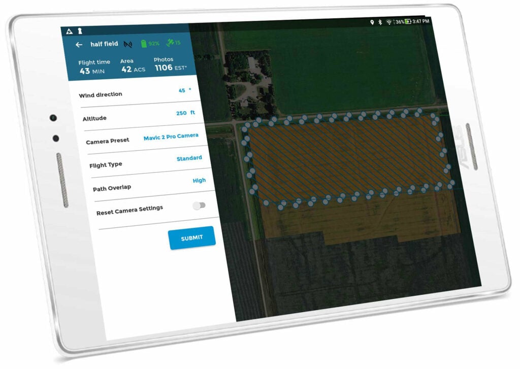
The Skyward drone management software platform has been integrated with Pix4D, allowing users to turn drone-gathered data into 2D maps and 3D models. In addition to planning flights, receiving approval to fly in controlled airspace with LAANC, and flying drones with Skyward’s InFlight ground control station, enterprises and drone pilots can now take advantage of Pix4D functionality to process data without having to leave the Skyward platform.

The new Pix4D-powered Skyward Mapping & Modeling functionality enables users to create, view, measure, and export 2D orthomosaic maps and 3D photogrammetric models from within Skyward’s web app. With this new capability, Skyward customers can get business-ready data sets through a seamless “plan, fly and process” workflow.

Mariah Scott, President of Skyward, commented: “Skyward has been bringing our customers tools to access airspace, plan, and fly — now they can produce business-ready data deliverables without leaving Skyward. Enterprises in construction, energy and utilities, and the public sector can get even more ROI out of their drone programs when combining Skyward’s drone management platform with Pix4D’s market-leading photogrammetry tools.”

Christopher Cressy, Pix4D Managing Director for North America, said: “Enterprises are seeking to scale their drone operations and transform their businesses with better data and faster time to insight. Skyward’s platform, along with the power of Pix4D, delivers a powerful, comprehensive solution.”

Find Drone Fleet Management Software Solutions >>

Posted by Mike Ball Mike Ball is our resident technical editor here at Unmanned Systems Technology. Combining his passion for teaching, advanced engineering and all things unmanned, Mike keeps a watchful eye over everything related to the unmanned technical sector. With over 10 years’ experience in the unmanned field and a degree in engineering, Mike’s been heading up our technical team here for the last 8 years. Connect & Contact

Latest Articles

Low- & Zero-Emission Propulsion & Power Generation Solutions for UAVs

NEX Power's hybrid propulsion technologies are designed to enable next-generation applications such as UAM and heavy-lift cargo drones

Feb 07, 2025
Most Read Articles on UST This Week

Here’s our round-up of the five most read articles on UnmannedSystemsTechnology.com this week

Feb 07, 2025
Project OPTIMAS to Utilize Schiebel VTOL UAS for Advanced Optical Laser Communications

Project OPTIMAS and Schiebel are set to develop a secure, high-speed optical communication system using quantum encryption and laser technology for multi-domain defence and satellite connectivity

Feb 07, 2025
Gemini 1200id High-Resolution Sonar Optimized for Unmanned Underwater Operations

Tritech's Gemini 1200id sonar offers high-resolution imaging, advanced noise reduction, and dual-frequency capability, enhancing performance for unmanned underwater systems and mission-critical ROV operations

Feb 07, 2025
Dockstr to Offer SubC Imaging’s Underwater Cameras & Software Solutions

SubC Imaging has announced Dockstr as its new agent, extending access to its advanced underwater cameras, DVRs, and remote operation systems across key offshore sectors worldwide

Feb 07, 2025
New NDAA-Compliant FPV Drone Camera Released 

Unusual Machines has launched the NDAA-compliant Fat Shark Aura FPV Camera, offering high-performance, first-person view capabilities for commercial and defense applications

Feb 07, 2025

Featured Content

Vertiq’s 81-08 G2 Module Added to DIU’s Blue UAS Framework

Vertiq's 81-08 G2 servo motor and control system for Group 2 sUAS has become the first motor and ESC combination to be approved under the U.S. government's Blue UAS Framework

Feb 05, 2025
Compact Remote ID Receiver Released for Enhanced Drone Safety

Dronetag has introduced RIDER, a pocket-sized, drone-agnostic Remote ID receiver designed to improve airspace situational awareness and support commercial and public safety applications

Jan 30, 2025
New GCS Software Released for C100 Quadcopter

Performance Drone Works introduces PDW CORE, a comprehensive software bundle enhancing the C100 quadcopter's capabilities with a new UI, flight simulator, mission planner, ATAK integration, and fleet management tools

Jan 29, 2025
Advanced Signal Mapping Tool Released for Effective UAV Flight Planning

Elsight has launched HeatSight, a signal strength mapping tool that provides UAV operators with reliable cellular coverage data, improving flight planning efficiency and safety for BVLOS missions

Jan 28, 2025
Doodle Labs Unveils Mobile App for Managing Mesh Networks

Doodle Labs is introducing the Mesh Rider® Mobile App, providing intuitive tools for managing wireless mesh networks across devices such as ground control stations (GCS) and UAVs

Jan 23, 2025
Advanced FOG-Based Inertial Sensing Solutions for Drones & Robotics

Aegiverse's products feature a multi-layered architecture that combines multiple elements into a compact module, providing significant, size, weight and cost reductions

Jan 21, 2025