Miniature LiDAR Sensor Selected for Autonomous Scanning System

By Mike Ball / 30 Jan 2021

Small LiDAR Sensors

Discover cutting-edge solutions from leading global suppliers
SUPPLIER SPOTLIGHT
Follow UST

Hovermap with Velodyne Lidar Puck LITE

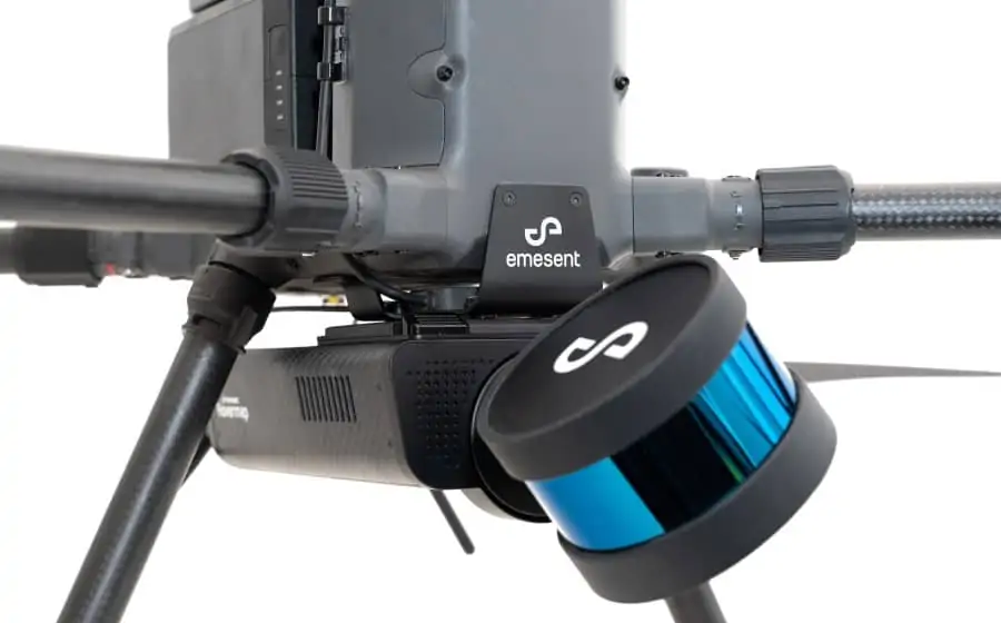
Velodyne Lidar has entered into an agreement to provide its Puck LITE LiDAR sensors to Emesent, developers of the Hovermap mobile scanning system for mapping hazardous and GPS-denied environments. Hovermap can be hand-held or mounted to a drone, and combines advanced collision avoidance and autonomous flight technologies to perform high-accuracy mapping in a wide range of environments, including challenging indoor and underground areas.

The Puck LITE is Hovermap’s primary perception and mapping sensor. The unit’s low weight and small size make it ideal for use in SWaP (size, weight and power)-constrained applications such as UAVs (unmanned aerial vehicles). It provides a full 360-degree environmental view and delivers real-time 3D data in high resolution.

Hovermap provides high-quality data capture for the mining, construction/infrastructure, forestry, defense, oil and gas, and film industries. The system features 3D point cloud colorization that provides additional context for visualization and analysis.

Daniel Thomas of drone cinematography provider XM2 commented: “When operating on a live set to capture VFX data in the film industry, speed is key. We use the Hovermap now to cover areas that traditionally had no effective lidar capture method, including above buildings and around complex set pieces, in a fraction of the time a terrestrial lidar takes. We can now operate between takes, capturing areas that would normally take an hour in five minutes.”

Dr. Stefan Hrabar, CEO of Emesent, said: “The Velodyne Puck LITE lidar is an extraordinary sensor for mobile mapping systems due to its compact size, light weight and high performance. The sensor helped us create game-changing technology that can obtain vital data in challenging environments in real time without risking the machine or operator safety.”

Anand Gopalan, CEO of Velodyne Lidar, added: “Emesent’s inventive use of Velodyne’s lidar sensors is enabling rapid autonomous mobile scanning that safely delivers operational insights in a range of applications. Hovermap provides an excellent showcase of how Puck LITE’s 360-degree capture capability enables companies to produce high quality, accurate, georeferenced point cloud data.”

Find manufacturers of miniature LiDAR for Drones & UAVs >>

Posted by Mike Ball Mike Ball is our resident technical editor here at Unmanned Systems Technology. Combining his passion for teaching, advanced engineering and all things unmanned, Mike keeps a watchful eye over everything related to the unmanned technical sector. With over 10 years’ experience in the unmanned field and a degree in engineering, Mike’s been heading up our technical team here for the last 8 years. Connect & Contact

Latest Articles

Most Read Articles on UST This Week

Here’s our round-up of the five most read articles on UnmannedSystemsTechnology.com this week

Apr 17, 2025
Updates on Conformal Coating & Tin Whiskers

SCS outlines updates on conformal coatings and tin whiskers, looking into the origin of tin whiskers, how to mitigate their adverse consequences with conformal coatings, and more

Apr 17, 2025
Quadratix Powers Multi-Domain UAS Operations with AI & Automation

General Atomics integrates its software expertise into Quadratix, a unified ecosystem designed to enhance multi-domain operations with AI, automation, and real-time data fusion across air, land, sea, cyber, and space, including unmanned systems

Apr 17, 2025
Integrated ROV Camera & DVR System Streamlines Visual Inspections

SubC Imaging outlines how its Rayfin SCI system simplifies underwater inspections by combining camera control and DVR functions into a single interface for ROV operators

Apr 17, 2025
ParaZero Unveils Advanced Parachute Recovery System for Critical Drone Operations

ParaZero launches the SafeAir M4, an advanced parachute recovery system designed for the DJI Matrice 4, enhancing drone safety, compliance, and mission readiness

Apr 17, 2025
The Evolution of Aurora Flight Sciences’ sUAS Platforms

Aurora Flight Sciences has spent more than ten years refining sUAS capabilities, and its evolving platforms now support a broad range of ISR missions

Apr 17, 2025

Featured Content

WarrenUAS Adds Another Top Expert in Sophisticated Unmanned Aircraft

WarrenUAS has announced a collaborative agreement with The Tactien Group, deepening its industry ties and expanding its leadership in unmanned aircraft systems training and research

Apr 15, 2025
​​​​Teledyne Marine Launches Compact Autonomous Navigation Solution at Ocean Business

Teledyne Marine has unveiled the Compact Navigator at Ocean Business 2025, an ultra-compact autonomous navigation system designed for ROVs and AUVs, optimizing size, power, and performance in a single lightweight unit

Apr 10, 2025
Greensea IQ to Present Autonomous EverClean Robot at Ocean Business 2025

Greensea IQ will introduce its hybrid EverClean Inspection Robot at Ocean Business 2025, showcasing advanced capabilities for underwater asset inspection and data collection

Apr 07, 2025
Advancing Unmanned Systems Through Strategic Collaboration UST works with major OEMs to foster collaboration and increase engagement with SMEs, to accelerate innovation and drive unmanned systems capabilities forward.