DJI and Skycatch to Deliver Industrial Construction Drone Fleet

By Mike Ball / 26 Mar 2018

Smart Sourcing for Unmanned Systems

Discover cutting-edge solutions from leading global suppliers
SUPPLIER SPOTLIGHT
Follow UST

Skycatch and DJI construction drone

DJI and commercial drone data company Skycatch have announced that they have extended their partnership to manufacture and deliver a fleet of high-precision drones for Komatsu Smart Construction. Each drone is manufactured by DJI and outfitted with specialized Skycatch technology, and is the first time DJI has manufactured a custom drone for a partner.

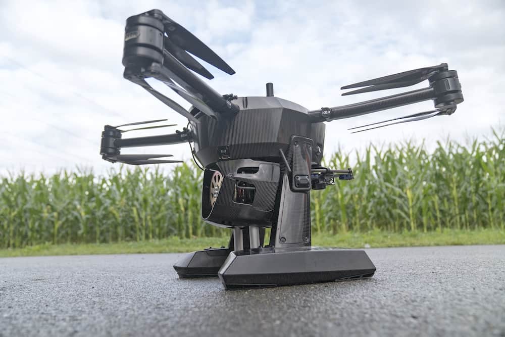
The Skycatch Explore1 drone autonomously flies over job sites to create highly accurate 3D site maps and models and will be deployed on Komatsu job sites. This map data will be used for Komatsu Smart Construction’s new data service that enables robotic earth moving equipment, used in the earthwork stage of the construction process, to correctly dig, bulldoze, and grade land autonomously according to digital construction plans.

“Conducting a site survey using a drone used to take hours. However, by implementing Explore1, users can carry out surveying quickly and easily. Now it is possible to perform drone surveying every day. Taking off, landing and flight route setting are all automated. Ground Control Points (GCPs) are no longer needed. 3D data is immediately generated and an entire construction site can be visually checked with the 3D map. The Explore1 is a true game changer for the construction site,” said Chikashi Shike, Executive Office of Smart Construction Division at Komatsu.

The Explore1 drone is built on DJI’s customizable Matrice 100 enterprise drone platform and is part of Skycatch’s High Precision Package along with the Edge1 RTK base station, a highly powerful ruggedized computer with software that locally processes drone images into precise 3D models regardless of wireless connectivity and location. Together, these technologies enable firms to create highly accurate maps and point clouds, discover costly job site mistakes, and predict schedule delays, saving up to tens of thousands of dollars per week.

“Being the first company to integrate into DJI’s manufacturing process will deliver incredible value to our customers worldwide,” said Christian Sanz, CEO at Skycatch. “By combining DJI’s mastery of hardware manufacturing and aerial technology with Skycatch’s data processing and customer expertise, we’ve created the most powerful and comprehensive solution for enterprise customers everywhere.”

“The Explore1 demonstrates DJI’s strategy to provide customers with the most powerful and reliable drone platforms on the market that can be tailored to the needs of any industry,” said Jan Gasparic, Head of Enterprise Partnerships at DJI. “Our close collaboration with Skycatch on this exciting program has resulted in a best-in-class solution of software and hardware for aerial surveying that truly changes the game for both our customers and the commercial drone industry.”

Posted by Mike Ball Mike Ball is our resident technical editor here at Unmanned Systems Technology. Combining his passion for teaching, advanced engineering and all things unmanned, Mike keeps a watchful eye over everything related to the unmanned technical sector. With over 10 years’ experience in the unmanned field and a degree in engineering, Mike’s been heading up our technical team here for the last 8 years. Connect & Contact

Latest Articles

Low- & Zero-Emission Propulsion & Power Generation Solutions for UAVs

NEX Power's hybrid propulsion technologies are designed to enable next-generation applications such as UAM and heavy-lift cargo drones

Feb 07, 2025
Most Read Articles on UST This Week

Here’s our round-up of the five most read articles on UnmannedSystemsTechnology.com this week

Feb 07, 2025
Project OPTIMAS to Utilize Schiebel VTOL UAS for Advanced Optical Laser Communications

Project OPTIMAS and Schiebel are set to develop a secure, high-speed optical communication system using quantum encryption and laser technology for multi-domain defence and satellite connectivity

Feb 07, 2025
Gemini 1200id High-Resolution Sonar Optimized for Unmanned Underwater Operations

Tritech's Gemini 1200id sonar offers high-resolution imaging, advanced noise reduction, and dual-frequency capability, enhancing performance for unmanned underwater systems and mission-critical ROV operations

Feb 07, 2025
Dockstr to Offer SubC Imaging’s Underwater Cameras & Software Solutions

SubC Imaging has announced Dockstr as its new agent, extending access to its advanced underwater cameras, DVRs, and remote operation systems across key offshore sectors worldwide

Feb 07, 2025
New NDAA-Compliant FPV Drone Camera Released 

Unusual Machines has launched the NDAA-compliant Fat Shark Aura FPV Camera, offering high-performance, first-person view capabilities for commercial and defense applications

Feb 07, 2025

Featured Content

Vertiq’s 81-08 G2 Module Added to DIU’s Blue UAS Framework

Vertiq's 81-08 G2 servo motor and control system for Group 2 sUAS has become the first motor and ESC combination to be approved under the U.S. government's Blue UAS Framework

Feb 05, 2025
Compact Remote ID Receiver Released for Enhanced Drone Safety

Dronetag has introduced RIDER, a pocket-sized, drone-agnostic Remote ID receiver designed to improve airspace situational awareness and support commercial and public safety applications

Jan 30, 2025
New GCS Software Released for C100 Quadcopter

Performance Drone Works introduces PDW CORE, a comprehensive software bundle enhancing the C100 quadcopter's capabilities with a new UI, flight simulator, mission planner, ATAK integration, and fleet management tools

Jan 29, 2025
Advanced Signal Mapping Tool Released for Effective UAV Flight Planning

Elsight has launched HeatSight, a signal strength mapping tool that provides UAV operators with reliable cellular coverage data, improving flight planning efficiency and safety for BVLOS missions

Jan 28, 2025
Doodle Labs Unveils Mobile App for Managing Mesh Networks

Doodle Labs is introducing the Mesh Rider® Mobile App, providing intuitive tools for managing wireless mesh networks across devices such as ground control stations (GCS) and UAVs

Jan 23, 2025
Advanced FOG-Based Inertial Sensing Solutions for Drones & Robotics

Aegiverse's products feature a multi-layered architecture that combines multiple elements into a compact module, providing significant, size, weight and cost reductions

Jan 21, 2025