Saab Seaeye Demonstrates AUV 4D Geospatial Data Acquisition System

By Caroline Rees / 13 Mar 2015

Geospatial Analysis Software

Discover cutting-edge solutions from 4 leading global suppliers
SUPPLIER SPOTLIGHT
Follow UST

Saab Seaeye SabertoothSaab Seaeye, a manufacturer of electric underwater vehicles, has demonstrated a 4D geo-spatial data acquisition system with real-time data visualisation for the company’s Sabertooth AUV. The demonstration was attended by representatives of twelve companies from seven countries, together with the Danish Navy, in Saab’s exclusive underwater test centre at Lake Vättern, Sweden.

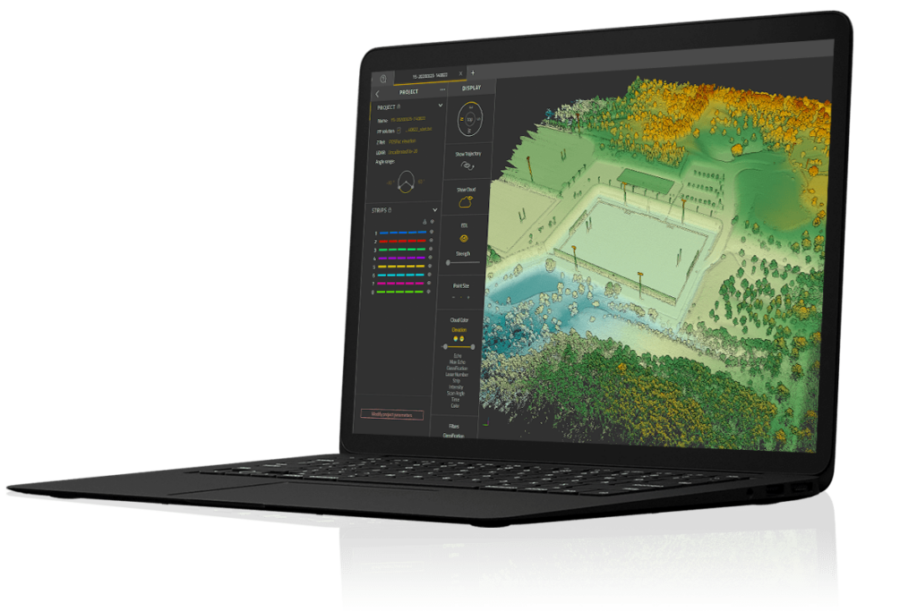
This advanced system has been configured for the Sabertooth by Saab QPS, a Saab Seaeye partner and leading developer of hydrographic survey and mapping software. Operators get a complete hydrographic data acquisition, navigation and processing software package that is fully integrated into the Sabertooth. The development unifies the QINSy and Fledermaus systems developed by Saab QPS into a single enhanced option for the Sabertooth.

QINSy is a data interface and acquisition software package that consolidates data acquired from different sensors in real-time. All acquired data can be viewed in various dedicated displays, which is ideal for real-time QA/QC of the data.

Fledermaus analyses and provides 4D visualisation of the acquired data, such as synchronised video, water column analysis, multi-beam sonars and pipe detection sensors.

For the demonstration the Sabertooth was equipped with a high-end sensor suite including side scan sonar, sub bottom profilers, high frequency imaging sonar, multibeam echo sounder and cameras, along with GPS, DVL and inertial measurement unit (IMU) supporting the navigation. Processing of the trajectory data was achieved with an algorithm developed by Saab Dynamics and renown for its navigational accuracy.

One demonstration included an extended autonomous survey mission performed to show the extent of the navigation accuracy and trajectory performance, as well as the quality of the high-resolution sonar images captured.

Another involved a range of autonomous missions in the lake including seabed survey, structure inspection, obstacle avoidance and a docking manoeuvre into an underwater docking station. A fibre link was used to allow live viewing of the data being gathered.

Visitors had an opportunity to examine the Sabertooth, a breakthrough hybrid concept that combines the autonomy and range of an AUV with the manoeuvrability and hovering capability of a light-work ROV – making it an ideal vehicle for long-range missions where there is a need to stop and conduct a detailed task.

Three operational modes are possible: autonomous roaming, attached fibre-optic cable, and umbilical for power and communications.

Fitted with the advanced Saab Seaeye iCON intelligent control system, its behaviour-based architecture offers a decision-making capability that can, in survey mode, react to unexpected data by deviating from a programmed mission to gather data or perform a task before resuming its mission plan.

It is intended that the Sabertooth can be left at deep and distant locations where it can operate from a remote subsea docking station ready to be launched on routine inspection, repair and maintenance work, and deal with emergencies.

At such a remote location, where it might remain for a year, tooling packages can be stored at its docking station where batteries can be re-charged, data and video downloaded and fresh instructions uploaded over the internet.

As offshore operators go deeper and into more difficult to access areas, the Sabertooth Hybrid AUV/ROV concept is attracting interest from those looking for a reliable and versatile underwater vehicle that can accommodate a wide range of data acquisition systems and tooling onto a single platform.

The strategic alliance between Saab Seaeye and Saab QPS bridges the gap between hardware and software development that is bringing innovative technology opportunities to the industry and setting new standards.

Posted by Caroline Rees Caroline co-founded Unmanned Systems Technology and has been at the forefront of the business ever since. With a Masters Degree in marketing Caroline has her finger on the pulse of all things unmanned and is committed to showcasing the very latest in unmanned technical innovation. Connect & Contact

Latest Articles

Low- & Zero-Emission Propulsion & Power Generation Solutions for UAVs

NEX Power's hybrid propulsion technologies are designed to enable next-generation applications such as UAM and heavy-lift cargo drones

Feb 07, 2025
Most Read Articles on UST This Week

Here’s our round-up of the five most read articles on UnmannedSystemsTechnology.com this week

Feb 07, 2025
Project OPTIMAS to Utilize Schiebel VTOL UAS for Advanced Optical Laser Communications

Project OPTIMAS and Schiebel are set to develop a secure, high-speed optical communication system using quantum encryption and laser technology for multi-domain defence and satellite connectivity

Feb 07, 2025
Gemini 1200id High-Resolution Sonar Optimized for Unmanned Underwater Operations

Tritech's Gemini 1200id sonar offers high-resolution imaging, advanced noise reduction, and dual-frequency capability, enhancing performance for unmanned underwater systems and mission-critical ROV operations

Feb 07, 2025
Dockstr to Offer SubC Imaging’s Underwater Cameras & Software Solutions

SubC Imaging has announced Dockstr as its new agent, extending access to its advanced underwater cameras, DVRs, and remote operation systems across key offshore sectors worldwide

Feb 07, 2025
New NDAA-Compliant FPV Drone Camera Released 

Unusual Machines has launched the NDAA-compliant Fat Shark Aura FPV Camera, offering high-performance, first-person view capabilities for commercial and defense applications

Feb 07, 2025

Featured Content

Vertiq’s 81-08 G2 Module Added to DIU’s Blue UAS Framework

Vertiq's 81-08 G2 servo motor and control system for Group 2 sUAS has become the first motor and ESC combination to be approved under the U.S. government's Blue UAS Framework

Feb 05, 2025
Compact Remote ID Receiver Released for Enhanced Drone Safety

Dronetag has introduced RIDER, a pocket-sized, drone-agnostic Remote ID receiver designed to improve airspace situational awareness and support commercial and public safety applications

Jan 30, 2025
New GCS Software Released for C100 Quadcopter

Performance Drone Works introduces PDW CORE, a comprehensive software bundle enhancing the C100 quadcopter's capabilities with a new UI, flight simulator, mission planner, ATAK integration, and fleet management tools

Jan 29, 2025
Advanced Signal Mapping Tool Released for Effective UAV Flight Planning

Elsight has launched HeatSight, a signal strength mapping tool that provides UAV operators with reliable cellular coverage data, improving flight planning efficiency and safety for BVLOS missions

Jan 28, 2025
Doodle Labs Unveils Mobile App for Managing Mesh Networks

Doodle Labs is introducing the Mesh Rider® Mobile App, providing intuitive tools for managing wireless mesh networks across devices such as ground control stations (GCS) and UAVs

Jan 23, 2025
Advanced FOG-Based Inertial Sensing Solutions for Drones & Robotics

Aegiverse's products feature a multi-layered architecture that combines multiple elements into a compact module, providing significant, size, weight and cost reductions

Jan 21, 2025