Aerologix Releases Automated Flight Path Technology Globally 

International customers can now download the AerologixFly app to access the patented Aeropath technology software, which offers an automated flight solution for inspecting vertical asset structures By Caroline Rees / 10 May 2023

Inspection Software

Discover cutting-edge solutions from 4 leading global suppliers
SUPPLIER SPOTLIGHT
Aerologix’s revolutionary technology takes flight
Follow UST

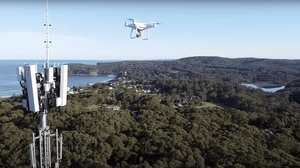
Australian drone technology startup Aerologix is releasing its patented automated flight path technology globally, for private and enterprise use, for potential use cases in search and rescue operations, disaster management and battling bushfires.

Previously restricted for use by pilots on the Aerologix app, international customers can now download the AerologixFly app to access the patented Aeropath technology software, which offers an automated flight solution for inspecting vertical asset structures. 

Aeropath is designed to help fly drones around complex structures, such as telecommunications towers, buildings and electricity structures, turning a low cost consumer drone into a valuable superdrone.  

Additional real-time communication features are scheduled to be added to the AerologixFly app in the next six months that have potential use cases such as search and rescue and bushfire monitoring. AeroLive will allow footage to be streamed live in HD, and AeroChat will allow users to give pilots instructions in real-time from an off-site location or command center.

Aerologix Co-Founder and COO, Rakesh Routhu, said, “Aeropath is the jewel in the Aerologix crown and we’re really excited to release it internationally, allowing pilots all over the world to benefit from our patented technology, which will undoubtedly optimize their operations whether they work for a company that requires frequent asset inspection or they do occasional private jobs as a side gig. Aeropath will allow them to complete missions efficiently and safely, every time.” 

Routhu continued: “We’re also really excited about our new features that will be released in the coming months. To be able to watch a live stream and communicate with the pilot in real-time will be a game-changer for not only enterprise customers, but especially for the likes of search and rescue or bushfire monitoring.”   

Available on iOS and Android phones and compatible with all DJI drones, Aeropath is available on the AerologixFly app, as a subscription based SaaS model on a month-to-month plan. For Australian pilots, Aeropath is currently only available when carrying out Aerologix projects.   

Aerologix Co-Founder and CEO, Tom Caska, said, “It’s been great to see so many pilots utilizing the platform already, before we’ve even advertised the service. We’ve seen hundreds of downloads from across New Zealand, USA, Norway, Finland, Canada, Singapore and Hong Kong. The drone pilot community is a very engaged community and when there is technology that will help them perform their jobs better, either via software or the drone itself, they don’t hesitate to get on board. We’re really excited to be able to service those pilots with what we think is brilliant technology.” 

Rakesh Routhu & Tom Caska, Co-founders, Aerologix

Find developers of Inspection Software for Drones & UAV >>

Posted by Caroline Rees Caroline co-founded Unmanned Systems Technology and has been at the forefront of the business ever since. With a Masters Degree in marketing Caroline has her finger on the pulse of all things unmanned and is committed to showcasing the very latest in unmanned technical innovation. Connect & Contact

Latest Articles

Low- & Zero-Emission Propulsion & Power Generation Solutions for UAVs

NEX Power's hybrid propulsion technologies are designed to enable next-generation applications such as UAM and heavy-lift cargo drones

Feb 07, 2025
Most Read Articles on UST This Week

Here’s our round-up of the five most read articles on UnmannedSystemsTechnology.com this week

Feb 07, 2025
Project OPTIMAS to Utilize Schiebel VTOL UAS for Advanced Optical Laser Communications

Project OPTIMAS and Schiebel are set to develop a secure, high-speed optical communication system using quantum encryption and laser technology for multi-domain defence and satellite connectivity

Feb 07, 2025
Gemini 1200id High-Resolution Sonar Optimized for Unmanned Underwater Operations

Tritech's Gemini 1200id sonar offers high-resolution imaging, advanced noise reduction, and dual-frequency capability, enhancing performance for unmanned underwater systems and mission-critical ROV operations

Feb 07, 2025
Dockstr to Offer SubC Imaging’s Underwater Cameras & Software Solutions

SubC Imaging has announced Dockstr as its new agent, extending access to its advanced underwater cameras, DVRs, and remote operation systems across key offshore sectors worldwide

Feb 07, 2025
New NDAA-Compliant FPV Drone Camera Released 

Unusual Machines has launched the NDAA-compliant Fat Shark Aura FPV Camera, offering high-performance, first-person view capabilities for commercial and defense applications

Feb 07, 2025

Featured Content

Vertiq’s 81-08 G2 Module Added to DIU’s Blue UAS Framework

Vertiq's 81-08 G2 servo motor and control system for Group 2 sUAS has become the first motor and ESC combination to be approved under the U.S. government's Blue UAS Framework

Feb 05, 2025
Compact Remote ID Receiver Released for Enhanced Drone Safety

Dronetag has introduced RIDER, a pocket-sized, drone-agnostic Remote ID receiver designed to improve airspace situational awareness and support commercial and public safety applications

Jan 30, 2025
New GCS Software Released for C100 Quadcopter

Performance Drone Works introduces PDW CORE, a comprehensive software bundle enhancing the C100 quadcopter's capabilities with a new UI, flight simulator, mission planner, ATAK integration, and fleet management tools

Jan 29, 2025
Advanced Signal Mapping Tool Released for Effective UAV Flight Planning

Elsight has launched HeatSight, a signal strength mapping tool that provides UAV operators with reliable cellular coverage data, improving flight planning efficiency and safety for BVLOS missions

Jan 28, 2025
Doodle Labs Unveils Mobile App for Managing Mesh Networks

Doodle Labs is introducing the Mesh Rider® Mobile App, providing intuitive tools for managing wireless mesh networks across devices such as ground control stations (GCS) and UAVs

Jan 23, 2025
Advanced FOG-Based Inertial Sensing Solutions for Drones & Robotics

Aegiverse's products feature a multi-layered architecture that combines multiple elements into a compact module, providing significant, size, weight and cost reductions

Jan 21, 2025