WingtraOne Drone Deployed for Wildfire Damage Assessment

By Mike Ball / 01 Dec 2020

Smart Sourcing for Unmanned Systems

Discover cutting-edge solutions from leading global suppliers
SUPPLIER SPOTLIGHT
Follow UST

WingtraOne mapping drone

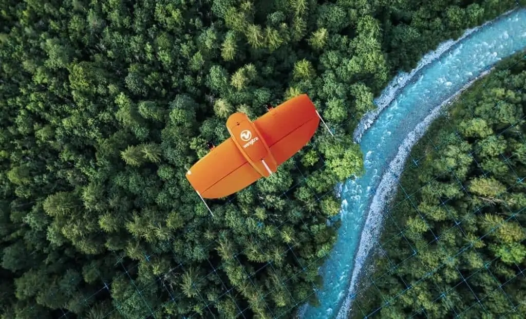
Wingtra’s WingtraOne VTOL (vertical take-off and landing) mapping UAV (unmanned aerial vehicle) has been deployed by the Lafayette City Police Department in California, in order to collect aerial data that was used to create 2D and 3D maps for assessing the extent of wildfire damage in the region.

One particular recent wildfire, known as the the CZU lightning complex fire, destroyed 86,509 acres (35,009 ha) and nearly 1500 structures across four communities and two state parks, necessitating a massive evacuation of the area. The WingtraOne drone was selected to help assess the damage due to its high-resolution imaging, the ability to cover a large area in a short time, and its custom elevation terrain following feature.

The Lafayette Police Department worked as part of an interagency task force and also partnered with geospatial consulting firm GeoAcuity. A public-facing portal was created for stakeholders, with the aerial maps providing victims with vital information such as data for insurance companies, and proof needed to raise funds.

The WingtraOne drone covered more than 1500 acres (600 ha) over the course of one day in four flights, navigating through massive forests and complex undulating terrain.

John Cornell, assistant to the chief of police at the City of Lafayette Police Department, commented: “The mapping not only helps search and rescue and damage assessment, but it also helps us see immediately what’s destroyed and what hazards need to be taken care of before we let people back into the area.”

“Redwoods are some of the biggest trees in the world, and there aren’t a whole lot of areas to launch from in a disaster area like this. You can’t just go onto somebody’s property and launch on top of their burned-out house. There are also a lot of crews working. So we needed to be as safe as possible and be able to predict precisely where the drone would land.”

Dr. Greg Crutsinger, Director of Applied Research at GeoAcuity, said: “I’ve seen like half a dozen GoFundMe website fundraisers that have our maps associated with them. The WingtraOne drone data is important to a range of people, from the public agencies involved to the residents who are desperate for information.”

Posted by Mike Ball Mike Ball is our resident technical editor here at Unmanned Systems Technology. Combining his passion for teaching, advanced engineering and all things unmanned, Mike keeps a watchful eye over everything related to the unmanned technical sector. With over 10 years’ experience in the unmanned field and a degree in engineering, Mike’s been heading up our technical team here for the last 8 years. Connect & Contact

Latest Articles

Enhancing Hurricane Data Collection Through Fixed-Wing UAV Technology

Explore Black Swift Technologies’ SØ UAS, which provides cost-effective, autonomous storm data collection, advancing tropical cyclone research and improving forecasting in hazardous environments

May 17, 2025
Most Read Articles on UST This Week

Here’s our round-up of the five most read articles on UnmannedSystemsTechnology.com this week

May 16, 2025
Next Generation Drone Safety and Security at XPONENTIAL 2025

ParaZero Technologies will present the enhanced SafeAir™ M4 parachute recovery system with triple sensor redundancy, and the DefendAir counter-UAS net launcher and DropAir precision delivery system at XPO25 in Houston

May 16, 2025
Improving Consistency in Complex PCB Assemblies with Automated Selective Soldering

San Francisco Circuits addresses the limitations of wave and hand soldering, offering selective soldering and full-service PCB assembly solutions for unmanned systems

May 16, 2025
Autopilot Systems Optimize Rim Driven Thrusters for New Hybrid USV

HydroSurv’s new REAV-47 Unmanned Surface Vehicle (USV) integrates a tailored autopilot interface from Dynautics with advanced rim-driven thrusters, enabling precise control for marine survey applications

May 16, 2025
Scaling Safe BVLOS Drone Operations with Automated Compliance

PG&E uses AirData’s automated platform to ensure safe, compliant BVLOS drone operations, enhancing efficiency and wildfire risk management across California

May 16, 2025

Featured Content

WarrenUAS Secures FAA 44807 Exemption, Expanding Large UAS Training Capabilities

WarrenUAS has received FAA 44807 approval to train students on unmanned aerial systems weighing over 55 pounds in the NAS, placing it among only five U.S. organizations with this clearance, and expanding its national training leadership

May 15, 2025
Product Spotlight: Durable Lightweight Lithium-Ion Batteries for UAVs

American Lithium Energy (ALE)'s energy-dense lithium-ion battery cells combine high power output with built-in safety features, ideal for UAV and eVTOL applications in challenging environments

May 14, 2025
SAE Media Group Releases Agenda for Counter UAS Middle East & Africa 2025

The inaugural Counter UAS Middle East & Africa 2025 will gather global defense leaders in Amman to explore threats, technologies, and strategies shaping regional drone defense

May 13, 2025
Advancing Unmanned Systems Through Strategic Collaboration UST works with major OEMs to foster collaboration and increase engagement with SMEs, to accelerate innovation and drive unmanned systems capabilities forward.