


Discover World-Leading Unmanned and Autonomous Technologies
Discover cutting-edge solutions from leading global suppliers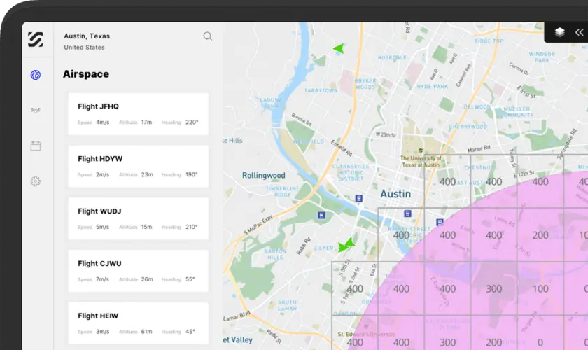
SkyGrid has launched a new application that enables UAV (unmanned aerial vehicle) operators and enterprises to automate every phase of drone flight in one unified software package. The SkyGrid Flight Control iPad app, powered by artificial intelligence (AI) and computer vision technologies, provides simplified mission planning and execution, allowing drone pilots to autonomously survey a defined area and detect objects in real-time. The new app is ideal for a wide variety of aerial applications, including search and rescue, disaster response, perimeter surveillance and site inspections.
Powered by SkyGrid’s AerialOS, SkyGrid Flight Control provides the following features and functionality:
Airspace intelligence: Provides a map of airspace classes, boundaries, temporary flight restrictions, notices to airmen, and other advisories
Ground intelligence: Displays population density, obstacles, elevation, and more
Advanced weather data: Details hyper-local precipitation, wind speed and direction, temperature, cloud cover, and more
Real-time airspace authorization: Automates authorization to fly in U.S. controlled airspace under 400 feet through integration with the Federal Aviation Administration’s Low Altitude Authorization and Notification Capability (LAANC) 4.0.
Automated mission planning: Automatically generates area exploration, waypoint, and multi-objective missions based on custom flight parameters, such as desired speed, altitude, and location
Autonomous flight execution: Autonomously launches the drone and performs the pre-defined flight plan
AI object recognition: Detects objects in real-time as a drone surveils the defined area with AI computer vision
More advanced enterprise features are also available that provide organizations with further advanced management of drones, pilots, and airspace operations. These features include AI-based mission planning and rerouting, multi-drone missions, custom object detection and counting, geofencing and alerts, and more.
Amir Husain, CEO and founder of SkyGrid, commented: “Traditionally, drone operators have used several different tools to check airspace, get LAANC, plan and execute flights, and gather insights, but it’s a manual, cumbersome process. Recognizing this challenge, SkyGrid has minimized the burden on drone operators by creating one solution that automates airspace, flights, and insights. As the only drone solution built on AI and blockchain technologies, we give operators and enterprises the assurances they need to execute safe, compliant missions.”
Steve Nordlund, vice president and general manager of Boeing NeXt and executive board advisor of SkyGrid, said: “SkyGrid Flight Control is an important stepping-stone to enable more complex commercial drone operations and advanced air mobility in urban, regional, and global markets. SkyGrid is solving complex problems in unmanned aviation with a system that will safely integrate the future volume of drones, passenger air vehicles, and other autonomous aircraft in the global airspace.”


