


Discover World-Leading Unmanned and Autonomous Technologies
Discover cutting-edge solutions from leading global suppliers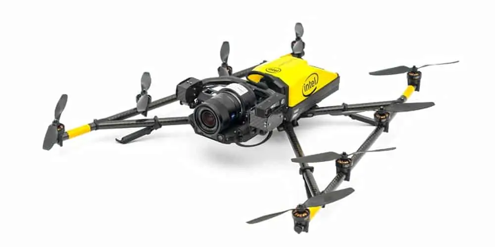
Intel unveiled details of the Intel Insight Platform, a digital asset management system enabling effective aerial data management and analyses, at the AUVSI Xponential 2018 trade show. It also demonstrated Intel Mission Control – next-generation flight planning software – and new updates for the Intel Falcon 8+ system: additional payloads for greater data capture, as well as distance hold and distance guard, both features of obstacle avoidance.
“We are pleased to announce a suite of new Intel drone technology at Xponential. Now companies can come to one supplier, and a name they know and trust, for their hardware and software needs – providing them with more tools to capture critical information about their assets, process and analyze it, and make insightful decisions for their business,”said Anil Nanduri, vice president and general manager of the Intel drone team.
The Intel Insight Platform has been deployed to strategic enterprise customers across several verticals. The Intel Insight Platform is a cloud-based digital asset management system that enables customers to store, share and manage the rich data that commercial drone systems collect. With that aerial data, Intel Insight Platform can generate 2D and 3D models, take measurements, enable sharing and collaboration across teams, and run data analytics. Intel worked with Delair in building capabilities that make Intel Insight Platform ready for enterprise customers.
Intel Mission Control Software is the next generation of flight planning, project management and data handling for the Intel Falcon 8+ system. It is designed to increase workflow efficiency and enhance automation of drone flights for commercial missions. Intel Mission Control enables Intel Falcon 8+ drone operators to create 2D and 3D flight plans for commercial surveying, mapping and inspection missions. Flight planning is automated with advanced preset mapping modes. Multiple layers of airspace information are integrated to support flight safety and compliance. Automatic pre-flight safety and system checks help validate the flight plan before the mission is executed. After the mission is completed, the software provides a quick preview of the collected data so the UAV operator can check and verify for adequate area coverage and overlap and even inspect the quality of individual images in a 3D format.
Intel Mission Control Software is currently in beta testing with customers as Intel continues to improve upon the advanced features and capabilities.
Intel announced three new payloads designed for inspection, surveying and mapping applications for the Intel Falcon 8+ system. The Intel High Resolution Imaging Payload captures 42MP images with high detail and clarity. It is based on the full-frame Sony RX1R II camera and generates highly detailed inspection data. This payload also supports RTK through a future software upgrade. The Intel Imaging Payload and Intel Dual Imaging Payload each support obstacle-avoidance capabilities to help enable safer missions and feature the 20MP Sony UMC-R10C camera. The payloads deliver real color, time-stamped and geo-referenced images for mapping, surveying and inspection. The Intel Dual Imaging Payload has two cameras mounted on one gimbal for simultaneous RGB image capture and thermal imaging.
Obstacle avoidance increases safety and reliability of complex missions. The Intel RealSense technology includes depth-sensing modules that compute raw image streams into high-resolution 3D depth maps. The obstacle-avoidance feature on the Intel Imaging and Intel Dual Imaging payloads enables the Intel Falcon 8+ drone to detect and avoid potential obstacles or hazards and has the ability to maintain and hold a set distance from an asset during inspection. Within a mission, objects are continually identified in real time and a 3D depth map of the environment is maintained in memory.
To further demonstrate Intel’s commitment to safe operations of unmanned aerial systems, the world’s first UL 3030 certification was presented to the Intel Falcon 8+ drone. The UL 3030 certifies the electrical safety protection of batteries, chargers and end products against electric shock and fire. This includes evaluating and testing for enclosure strength, functional safety requirements, motor safety, and protection against injury, performance and autonomous features. The Intel Falcon 8+ drone is the first to earn this certificate.


