


Discover World-Leading Unmanned and Autonomous Technologies
Discover cutting-edge solutions from leading global suppliers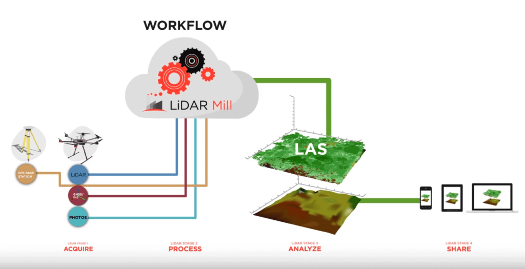

Phoenix LiDAR Systems has announced the release of the new LiDAR Mill platform, the first cloud-based, fully automated LiDAR post-processing tool.
Historically, the large quantities of raw data generated by laser-based UAV (unmanned aerial vehicle) mapping systems has made processing a resource-intensive and sometimes cost prohibitive factor for many organizations. With LiDAR Mill, users can now upload raw mapping data directly to the cloud service and download processed data files in the industry-standard LAS format, with significant time and cost savings.
The LiDAR Mill platform breaks the formerly manual and highly technical post-processing procedure into three automated steps, or “pipelines.” The first, christened as the NavLab Pipeline, is a trajectory module that processes inertial and GNSS (Global Navigation Satellite System) data in forward and reverse several times to achieve the greatest possible accuracy. This trajectory is then fused with 3-dimensional XYZ LiDAR data to create an unfiltered LAS file, which can be further refined through other processing algorithm pipelines, like flight line matching, filtering, and more. The final product is a calibrated and “de-noised” point cloud with basic “ground/non-ground” classification. LiDAR Mill users can then download their data for further processing, or simply forward it to customers as a final deliverable.
As LiDAR technology becomes increasingly affordable, organizations seeking to conduct surveying or mapping operations can further take advantage of customizable solutions within the LiDAR Mill platform. The NavLab Pipeline, for example, can be used as a stand-alone module just for trajectory processing, or as the starting point for additional pipelines, like planimetrics, advanced classification, DTM (Digital Terrain Model) creation, and more.
“We’re excited to launch LiDAR Mill because it fills that gap in the UAV LiDAR mapping puzzle,” says CEO Grayson Omans, “it makes post-processing faster and affordable so that more organizations can use it.”
The use of LiDAR for mapping and surveying has long been a preferred method for teams in mining, utilities, forestry, and more. As the industry grows and hardware becomes more affordable, LiDAR Mill further drives down costs by automating post-processing and leveraging cloud computing. Phoenix LiDAR’s new platform enables even more companies to take advantage of the detailed 3D data LiDAR offers.


