


Discover World-Leading Unmanned and Autonomous Technologies
Discover cutting-edge solutions from leading global suppliers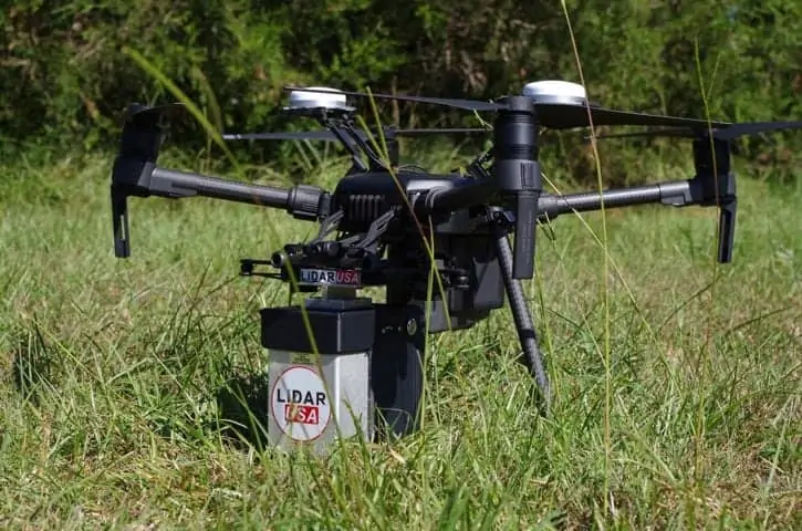
Cepton Technologies, a developer of 3D LiDAR sensing solutions, has announced the launch of SORA 200, its new lightweight 3D LiDAR sensor, at the annual Commercial UAV Expo. SORA 200 delivers long-range, high-resolution and low-cost mapping capabilities for unmanned aerial vehicles (UAVs). The launch of SORA 200 follows Cepton’s recent unveiling of its HR80 series of high-performance 3D LiDAR products for ground applications.
Cepton is partnering with LiDAR USA, a total LiDAR geospatial solutions company, to bring SORA 200 to market. LiDAR USA is Cepton’s first reseller and system integrator in the UAV mapping industry.
“To meet the increasing demands of UAVs, LiDAR sensors must be long-range, lightweight and high-resolution,” said Dr. Mark McCord, co-founder and VP of engineering at Cepton. “SORA 200 allows for highly efficient 3D map data production at increased altitudes and velocities in various environments. With 200-meter range and a weight of just 550 grams, SORA 200 is the lightest high-performance UAV LiDAR on the market today. We are thrilled to partner with LiDAR USA on this product to bring a new solution to the UAV mapping industry.”
Cepton’s micro-motion LiDAR technology removes expensive, ungainly spinning parts common in traditional LiDAR units, resulting in smaller and more reliable sensors that do not compromise on resolution or range. Use of off-the-shelf materials reduces delivery wait time and overall cost.
“For years, the UAV mapping industry has been waiting for a long-range, lightweight and low-cost 3D LiDAR solution,” said Jeff Fagerman, CEO of LiDAR USA. “No one has been able to produce anything like SORA 200. We are very excited that Cepton is fulfilling this market need.”
Product highlights include:
- Lightweight: At 550 grams, the SORA 200 can be deployed in situations where payload weight matters. Its light weight means that UAVs enabled with SORA 200 can fly for longer trips.
- Long-range: With its scanning range extending up to 200 meters, the SORA 200 allows UAVs to fly at higher altitudes and cover more ground.
- High-frame rate: With a 200-hertz frame rate, UAVs equipped with the SORA 200 can operate faster while maintaining high-density map data acquisition.


