UAS Students to use Augmented Reality Software for Disaster Relief Study

By Mike Ball / 04 Jun 2017

Smart Sourcing for Unmanned Systems

Discover cutting-edge solutions from leading global suppliers
SUPPLIER SPOTLIGHT
Follow UST

Embry-Riddle UAS student

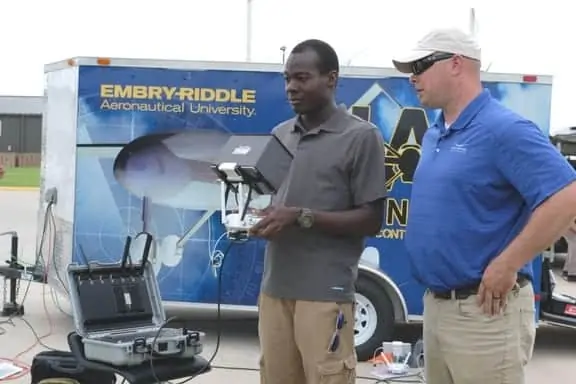
Rapid Imaging Software has announced that unmanned aircraft systems (UAS) students from Embry-Riddle Aeronautical University will use the company’s SmartCam3D View augmented reality software in the UAS/Severe Weather Disaster Relief Operations Study Away Program taking place in Oklahoma. During the study, students will learn operational and coordination requirements associated with UAS in support of disaster relief operations in partnership with the Oklahoma Department of Emergency Management.

SmartCam3D View shows map data such as street names and points of interest as overlays on video. This information assists the UAS pilot with safe flight operations and enhances disaster relief operations such as:

  • Searching for missing persons or survivors
  • Determining extent of damage to homes or infrastructure
  • Directing emergency response teams to safe routes to affected areas
  • Finding damaged infrastructure, storm drains or fire hydrants
  • Avoiding flight hazards,power lines and towers

“Embry Riddle is a leader in UAS education and we wanted to expose students to the best AR technology available”, stated David Geisler, Vice President of Operations for Rapid Imaging Software. “We believe that drones equipped with AR will save lives and crucial time for agencies.”

Dr. Joseph Cerreta, Embry Riddle Assistant Professor of Aeronautical Science, noted, “Students will operate under the FAA’s Part 107 sUAS rule using thermal imaging cameras, loaned from Rocky Mountain Unmanned Systems (RMUS), to effectively operate at night in search and rescue operations under a Certificate of Waiver. Thermal cameras with Rapid Imaging Software’s augmented reality can make night operations safer and more effective for first responders.”

The goal of the study is to teach students how UAS can assist local communities when disaster strikes.

Posted by Mike Ball Mike Ball is our resident technical editor here at Unmanned Systems Technology. Combining his passion for teaching, advanced engineering and all things unmanned, Mike keeps a watchful eye over everything related to the unmanned technical sector. With over 10 years’ experience in the unmanned field and a degree in engineering, Mike’s been heading up our technical team here for the last 8 years. Connect & Contact

Latest Articles

Most Read Articles on UST This Week

Here’s our round-up of the five most read articles on UnmannedSystemsTechnology.com this week

Jul 11, 2025
Vertiq Speed Firmware v0.1.1 Now Available with Bug Fixes

Vertiq has released firmware v0.1.1 to correct a parameter bug affecting telemetry and 3D mode settings on select G1 and G2 modules

Jul 11, 2025
The Role of ROVs in Unmanned Marine Operations

Oceanbotics has answered the most common questions about ROVs, covering how they work, where they're used, and key capabilities

Jul 11, 2025
LiveU File Transfer Speeds Up Drone Data Delivery for Critical Missions

LiveU’s File Transfer enables rapid transmission of large drone data files, reducing delays and supporting faster decision-making in public safety and infrastructure operations.

Jul 11, 2025
Exploring Differences Between M9PLUS & M9 GNSS Antennas

Discover the key upgrades in Maxtena’s new M9PLUS GNSS antenna, including improved performance, signal purity, and multipath mitigation over the original M9

Jul 11, 2025
USAF Uses Inertial Labs Drone Lidar for Tree Obstruction Survey

The US Air Force successfully used Inertial Labs drone Lidar and cloud software to quickly map tree obstructions at Joint Base Lewis-McChord (JBLM), improving airfield safety

Jul 11, 2025

Featured Content

USAF Uses Inertial Labs Drone Lidar for Tree Obstruction Survey

The US Air Force successfully used Inertial Labs drone Lidar and cloud software to quickly map tree obstructions at Joint Base Lewis-McChord (JBLM), improving airfield safety

Jul 11, 2025
New UAV to Combine Solar Hydrogen & Battery Power for Extended Flight

XSun and H3 Dynamics are developing the first UAV powered by solar, hydrogen, and batteries, aiming to deliver zero-emission, long-endurance unmanned flight

Jul 07, 2025
Enhancing Mangrove Restoration Through 3D Printed Drone Design

Explore how Inverto Earth, in collaboration with HP Additive, is using sustainable 3D printing and drone technology to drive large-scale mangrove restoration and protect vulnerable coastal ecosystems

Jul 03, 2025
Advancing Unmanned Systems Through Strategic Collaboration UST works with major OEMs to foster collaboration and increase engagement with SMEs, to accelerate innovation and drive unmanned systems capabilities forward.