


Discover World-Leading Unmanned and Autonomous Technologies
Discover cutting-edge solutions from leading global suppliers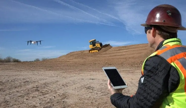
John Deere and Kespry have announced an exclusive global strategic alliance through which John Deere Construction & Forestry dealers will provide the Kespry Aerial Intelligence System to their customers on job sites around the world. Starting in North America, the alliance enables John Deere customers to use Kespry’s fully integrated industrial drone platform to capture topographic data in minutes with survey-grade accuracy.
“This technology will help our dealers offer a seamless workflow to site development and road building contractors from project planning through grading dirt,” said Andrew Kahler, product marketing manager, John Deere WorkSight. “The data gathered from the Kespry system will help our customers and equipment operators make decisions that reduce costs and improve productivity as they optimize the job site and spend less time on jobs.”
Kespry delivers a fully automated drone system that takes off, flies a designated flight path and lands, all without operator intervention. With the Kespry Drone 2s now available across the John Deere network, customers can easily create missions and capture, analyze and share survey-grade data and insights.
“Our relationship with John Deere will accelerate the adoption of drone solutions in industrial markets and will rapidly change how business is done in construction, road building and other industrial sectors,” said George Mathew, chairman and CEO of Kespry. “These advanced aerial intelligence systems are already changing the face of work in industrial markets as surveyors and contractors are able to retool their skill sets for this increasingly connected world.”
John Deere chose Kespry based on its interoperability with John Deere WorkSight technologies and ease of use for customers. The agreement between the two companies includes Kespry working with John Deere dealers to train and certify them in the use of the Kespry 2s platform.
The Kespry Drone 2s flies autonomously, without manual piloting, and uses sensors to avoid obstacles. To help customers operating in congested areas, the drones include an on-board LiDAR sensor that automatically detects and avoids obstacles such as trees, cranes and buildings.
The post-processed data will be accessible from anywhere in the world via a web interface, allowing customers to access real-time 3D renderings, volumetric analysis and data export features. The drone-collected data can then be exported from the Kespry cloud to a number of common modeling packages including AGTEK Earthwork 4D, another endorsed John Deere solution to perform 3D model overlays, cut/fill maps, bidding and takeoff procedures.


