


Discover World-Leading Unmanned and Autonomous Technologies
Discover cutting-edge solutions from leading global suppliers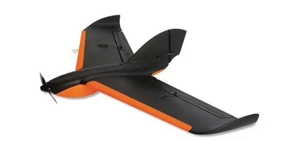
Sentera, LLC, a global provider of UAV hardware, sensors and data management platforms, has announced the launch of its Phoenix 2 Fixed-Wing Unmanned Aerial Vehicle (UAV).
“The Phoenix 2 brings a level of precision and accuracy to UAVs that hasn’t been seen before,” said Todd Colten, chief aerospace engineer for Sentera. “Users can now collect highly detailed data quickly, and with complete certainty about its accuracy.” Colten went on to describe the professional-grade autopilot: “The grid pattern you specify is mapped pre-flight. The drone knows exactly what line to follow to get the exact looping radius, and the exact flight level needed for perfect tiling.”
At four pounds, the Phoenix 2 is easily hand-launched in just a few steps, and can carry multiple sensor options for up to an hour of flight time. The professional-grade autopilot constantly auto-calculates and auto-optimizes according to the grid pattern specified to ensure the data collected meets exact specifications.
Find suppliers of Fixed Wing UAVs >
“Growers are using the Phoenix 2 with agriculture-specific sensors to collect RGB, NIR, and NDVI imagery. That imagery is so precise – [the growers] tell us they’re targeting and treating specific parts of their fields, and then they’re using fewer chemicals, saving money and increasing yields,” continued Colten. “Follow-up flights can be programmed to use the same pattern for exact data comparison at multiple times throughout the growing season. We’re getting great feedback from our customers.”
The Phoenix 2 is a highly-versatile UAV that accepts multiple sensors, including the Sentera Double 4K Sensor, providing true RGB and normalized difference vegetation index (NDVI) data in a single flight. The Sentera Quad Sensor, a multi-spectral six-band imager with red edge capabilities is also popular in agriculture applications. Other compatible mapping sensors include the Sentera-Q for high-resolution orthomaps and the Radiometric Thermal Sensor, which quickly builds high-resolution true temperature maps. Sentera also offers EO and IR gimbaled payloads for live video public safety missions.
With up to a 60-minute endurance and cruise speed of 30 mph, the Phoenix 2 is capable of covering broad areas. The accurate Kestrel OnBoard autopilot ensure images are captured with precise, even spacing and overlap that is auto-calculated and can be adjusted by the user at the click of a button.
Hand-launched in just a few steps, the four-pound Phoenix 2 flies autonomously on a predetermined flight pattern that can be updated during flight by accessing the easy-to-use ground station software. Upon completion, the Phoenix 2 automatically returns to safely land.
The Phoenix 2 solution includes the aircraft, ground station, transportation cases, batteries, chargers, and software with multiple training options available. Sentera’s AgVault and OnTop Open Software Platforms manage the multitude of images and data collected during flight, and allow near-real time reading and analysis of the data, including working with other data sources via APIs.


