Trimble Obtains FAA Exemption to Fly UX5 UAS

By Caroline Rees / 12 Dec 2014

Smart Sourcing for Unmanned Systems

Discover cutting-edge solutions from leading global suppliers
SUPPLIER SPOTLIGHT
Follow UST

Trimble UX5Trimble has announced that the Federal Aviation Administration (FAA) has granted an exemption that will allow the company to conduct commercial operation of its Trimble® UX5 Aerial Imaging Solution in the U.S. The exemption was granted pursuant to Section 333 of the FAA Modernization and Reform Act of 2012, which authorizes the FAA to grant exemptions from FAA rules limiting commercial operation of Unmanned Aircraft Systems (UAS) pending the adoption of permanent rules. Section 333 exemptions are intended to “provide a pathway for civil operators who desire safe and legal entry” 1 into the U.S. National Airspace System (NAS).

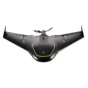
The Trimble UX5 is an unmanned fixed-wing aircraft targeted at the surveying, agriculture, oil & gas, mining, construction, environmental industries. The system autonomously captures a series of high-resolution images during flight, which is typically up to 50 minutes covering as much as 2.3 square kilometers (approximately 1 square mile) when flying 120 meters (approximately 400 feet) above the ground. Using Trimble Business Center Aerial Photogrammetry software, images are used to easily generate 2D and 3D deliverables such as orthomosaic images, three-dimensional point clouds and contour maps. The Trimble UX5 enables the collection of large amounts of data, often faster than traditional surveying or mapping technologies.

“We are pleased to be among the first companies to receive an exemption from the FAA authorizing commercial operation of UAS,” said Erik Arvesen , vice president of Trimble’s Geospatial Division. “This decision reflects Trimble’s efforts to responsibly operate its UAS business in the U.S. while the FAA addresses air safety issues in opening the NAS for commercial UAS operations on a broader scale. Trimble will continue its efforts to support the FAA’s decision-making process and to provide opportunities for our customers to safely use the UX5 to capture accurate geospatial data for a wide range of applications such as surveying, oil & gas, mining, construction and many more.”

“In the agriculture market, the FAA exemption moves Trimble one step further with the opportunity to provide a solution for safe and legal UAS operations that can benefit growers, ranchers, water management contractors, agronomists and other ag service providers,” said Joe Denniston , vice president of Trimble’s Agriculture Division. “High-speed aerial imaging is a powerful tool that can quickly and easily capture aerial images for scouting and monitoring crop health, locating cattle and their available forage over large areas, measuring crop height, and generating topographic maps and models for land leveling and drainage applications. As a result, the system can be a powerful data collection tool that can aid with recommendations to improve farming operations.”

Posted by Caroline Rees Caroline co-founded Unmanned Systems Technology and has been at the forefront of the business ever since. With a Masters Degree in marketing Caroline has her finger on the pulse of all things unmanned and is committed to showcasing the very latest in unmanned technical innovation. Connect & Contact

Latest Articles

Most Read Articles on UST This Week

Here’s our round-up of the five most read articles on UnmannedSystemsTechnology.com this week

Apr 17, 2025
Updates on Conformal Coating & Tin Whiskers

SCS outlines updates on conformal coatings and tin whiskers, looking into the origin of tin whiskers, how to mitigate their adverse consequences with conformal coatings, and more

Apr 17, 2025
Quadratix Powers Multi-Domain UAS Operations with AI & Automation

General Atomics integrates its software expertise into Quadratix, a unified ecosystem designed to enhance multi-domain operations with AI, automation, and real-time data fusion across air, land, sea, cyber, and space, including unmanned systems

Apr 17, 2025
Integrated ROV Camera & DVR System Streamlines Visual Inspections

SubC Imaging outlines how its Rayfin SCI system simplifies underwater inspections by combining camera control and DVR functions into a single interface for ROV operators

Apr 17, 2025
ParaZero Unveils Advanced Parachute Recovery System for Critical Drone Operations

ParaZero launches the SafeAir M4, an advanced parachute recovery system designed for the DJI Matrice 4, enhancing drone safety, compliance, and mission readiness

Apr 17, 2025
The Evolution of Aurora Flight Sciences’ sUAS Platforms

Aurora Flight Sciences has spent more than ten years refining sUAS capabilities, and its evolving platforms now support a broad range of ISR missions

Apr 17, 2025

Featured Content

WarrenUAS Adds Another Top Expert in Sophisticated Unmanned Aircraft

WarrenUAS has announced a collaborative agreement with The Tactien Group, deepening its industry ties and expanding its leadership in unmanned aircraft systems training and research

Apr 15, 2025
​​​​Teledyne Marine Launches Compact Autonomous Navigation Solution at Ocean Business

Teledyne Marine has unveiled the Compact Navigator at Ocean Business 2025, an ultra-compact autonomous navigation system designed for ROVs and AUVs, optimizing size, power, and performance in a single lightweight unit

Apr 10, 2025
Greensea IQ to Present Autonomous EverClean Robot at Ocean Business 2025

Greensea IQ will introduce its hybrid EverClean Inspection Robot at Ocean Business 2025, showcasing advanced capabilities for underwater asset inspection and data collection

Apr 07, 2025
Advancing Unmanned Systems Through Strategic Collaboration UST works with major OEMs to foster collaboration and increase engagement with SMEs, to accelerate innovation and drive unmanned systems capabilities forward.