3D Imaging System Integrated on Arcturus T-20 UAV

By Caroline Rees / 24 Jan 2014

Smart Sourcing for Unmanned Systems

Discover cutting-edge solutions from leading global suppliers
SUPPLIER SPOTLIGHT
Follow UST

Arcturus T-20 unmanned aerial vehicle with 3D imaging pods

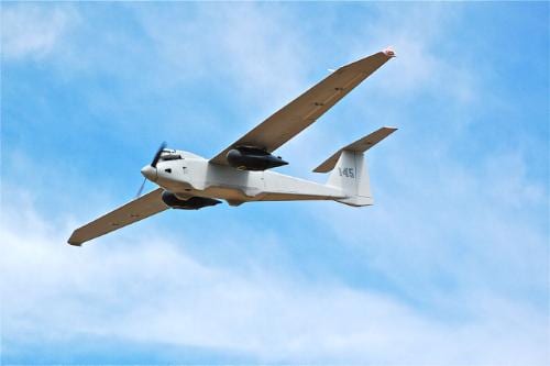
The GeoDragon sensor system has now been integrated and flown on an Arcturus UAV T-20 Tier II unmanned aerial vehicle. The sensor system is enclosed in a wing-mounted pod and is capable of high resolution 2-D and 3-D image capture. The sensor was designed by Urban Robotics in Portland, Oregon. The aircraft was built by Arcturus UAV in Rohnert Park, California. The GeoDragon system can create 3-D reconstructions in near-real time and output high-resolution digital elevation models, LIDAR-like datasets, and wide area maps. The system will be released in mid-2014. GeoDragon adds significant 3-D imaging and mapping capabilities to the T-20 UAV.

The unique aspects of the system are low weight (equating to longer endurance and loiter time,) small operational footprint on the ground (1 or 2 full size pick-up trucks,) a quick mount/dismount pod, quiet operation (the T-20 utilizes a modified 4-stroke engine,) and the ability to fly simultaneously with other payloads on the T-20, such as EO/IR.

GeoDragon imagery is post-processed using automated 3-D algorithms to rapidly generate large mapping and modeling datasets. Urban Robotics develops software and hardware solutions for 3-D ISR, remote sensing and geospatial applications, including collection, post-processing, and data management.

The T-20 is a runway independent, Tier II class, small tactical unmanned aerial vehicle with a technical readiness level (TRL) 9. The primary mission of the Arcturus UAV is intelligence, surveillance and reconnaissance. Typical missions include aerial mapping, drug interdiction, fire-fighting, border patrol, force protection, search and rescue, as well as military ISR. Payloads include full motion video from daylight and infrared cameras. Video is then transmitted by secure data link to mission commanders on the ground. An onboard GPS autopilot with waypoint navigation accepts multiple flight plans from the Ground Control Station, allowing the T-20 to return to a specified location autonomously after up to 16 hours of flight. The T-20 is powered by a 190cc an air-cooled, four-stroke, fuel injected engine. Carbon fiber composite construction used in the T-20 airframe allows for payloads up to 65 lbs.

Posted by Caroline Rees Caroline co-founded Unmanned Systems Technology and has been at the forefront of the business ever since. With a Masters Degree in marketing Caroline has her finger on the pulse of all things unmanned and is committed to showcasing the very latest in unmanned technical innovation. Connect & Contact

Latest Articles

Low- & Zero-Emission Propulsion & Power Generation Solutions for UAVs

NEX Power's hybrid propulsion technologies are designed to enable next-generation applications such as UAM and heavy-lift cargo drones

Feb 07, 2025
Most Read Articles on UST This Week

Here’s our round-up of the five most read articles on UnmannedSystemsTechnology.com this week

Feb 07, 2025
Project OPTIMAS to Utilize Schiebel VTOL UAS for Advanced Optical Laser Communications

Project OPTIMAS and Schiebel are set to develop a secure, high-speed optical communication system using quantum encryption and laser technology for multi-domain defence and satellite connectivity

Feb 07, 2025
Gemini 1200id High-Resolution Sonar Optimized for Unmanned Underwater Operations

Tritech's Gemini 1200id sonar offers high-resolution imaging, advanced noise reduction, and dual-frequency capability, enhancing performance for unmanned underwater systems and mission-critical ROV operations

Feb 07, 2025
Dockstr to Offer SubC Imaging’s Underwater Cameras & Software Solutions

SubC Imaging has announced Dockstr as its new agent, extending access to its advanced underwater cameras, DVRs, and remote operation systems across key offshore sectors worldwide

Feb 07, 2025
New NDAA-Compliant FPV Drone Camera Released 

Unusual Machines has launched the NDAA-compliant Fat Shark Aura FPV Camera, offering high-performance, first-person view capabilities for commercial and defense applications

Feb 07, 2025

Featured Content

Vertiq’s 81-08 G2 Module Added to DIU’s Blue UAS Framework

Vertiq's 81-08 G2 servo motor and control system for Group 2 sUAS has become the first motor and ESC combination to be approved under the U.S. government's Blue UAS Framework

Feb 05, 2025
Compact Remote ID Receiver Released for Enhanced Drone Safety

Dronetag has introduced RIDER, a pocket-sized, drone-agnostic Remote ID receiver designed to improve airspace situational awareness and support commercial and public safety applications

Jan 30, 2025
New GCS Software Released for C100 Quadcopter

Performance Drone Works introduces PDW CORE, a comprehensive software bundle enhancing the C100 quadcopter's capabilities with a new UI, flight simulator, mission planner, ATAK integration, and fleet management tools

Jan 29, 2025
Advanced Signal Mapping Tool Released for Effective UAV Flight Planning

Elsight has launched HeatSight, a signal strength mapping tool that provides UAV operators with reliable cellular coverage data, improving flight planning efficiency and safety for BVLOS missions

Jan 28, 2025
Doodle Labs Unveils Mobile App for Managing Mesh Networks

Doodle Labs is introducing the Mesh Rider® Mobile App, providing intuitive tools for managing wireless mesh networks across devices such as ground control stations (GCS) and UAVs

Jan 23, 2025
Advanced FOG-Based Inertial Sensing Solutions for Drones & Robotics

Aegiverse's products feature a multi-layered architecture that combines multiple elements into a compact module, providing significant, size, weight and cost reductions

Jan 21, 2025