


Discover World-Leading Unmanned and Autonomous Technologies
Discover cutting-edge solutions from leading global suppliers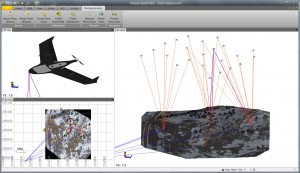
Trimble Introduces Photogrammetry Functionality to its Trimble Business Center Software for Surveyors
Trimble has introduced a new version of its office surveying software—Trimble® Business Center Software version 3.00. Trimble Business Center Software version 3.00 is a powerful, next generation surveying office software suite designed to manage, analyze and process all field survey data, including optical, GNSS and imaging data. The new version features photogrammetry enhancements, including the ability to process images from the Gatewing X100 unmanned aerial system (UAS). These enhancements provide surveyors with increased visualization and processing capabilities allowing them to further maximize productivity and create aerial survey deliverables.
“Powerful and intuitive, Trimble Business Center and its integration with UAS data introduces new capabilities to surveyors and represents a significant leap in efficiency. Surveyors, engineers and geospatial data managers can increase their productivity, efficiency and quality of deliverables through the software’s aerial data processing capabilities,” said Erik Arvesen, vice president of Trimble’s Survey Division. “Traditional sites, such as large mines, that in the past have taken days to map using conventional methods can now be accurately modeled in just hours.”
Version 3.00 introduces a new photogrammetry module for importing and working with flight data and images collected from the Gatewing X100 UAS and optical instruments, such as the Trimble S8 with Trimble VISION™ technology, which integrates calibrated digital cameras to collect survey data, stream video from the perspective of the instrument and capture panoramic still images. Based on state-of-the art software from Inpho, a Trimble solution known for 30 years of digital aerial photogrammetry leadership, the Trimble Business Center photogrammetry module also provides office surveyors with the capability to process complete mapping projects containing aerial data, GNSS and total station observations. Surveyors can produce deliverables, including georeferenced orthophotos, 3D point clouds and digital surface models directly from Trimble Business Center.
With the ability to integrate photogrammetry with data collected from GNSS receivers, total stations, and digital levels, surveyors can combine aerial images with GNSS measurements on ground control points and 3D laser scans of buildings to precisely, comprehensively and efficiently map large and complex sites.
The new version also introduces 64-bit processing. As a 64-bit application, Trimble Business Center allows surveyors in the office to utilize their computer’s RAM, maximizing the productivity of the surveyor’s workstation, to display large images and point clouds for increased visualization functionality. Users can also display large images seamlessly; images “tile” automatically on import and the displayed resolution adjusts seamlessly as users zoom in and out for superior image viewing.
“Inpho is a proven leader in digital aerial photogrammetry,” said Arvesen. “Trimble has taken that expertise and applied it to the survey market, as we pioneer the development of UAS data integration for surveyors.”
Availability
Trimble Business Center Software version 3.00 and the photogrammetry module are available now through Trimble’s Survey Distribution Channel. In addition, Trimble Business Center version 2.90 is also available for users who are limited to 32-bit systems. For more information, visit: www.trimble.com/TBC-Survey.


