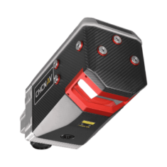
The AlphaAir 2400 is an airborne laser scanner offering an impressive combination of low weight, extended range, high accuracy, and scanning speed for missions at up to 1400 m operating flight altitude. The AA2400 can be easily installed on helicopters or airplanes but also on various UAVs, such as CHCNAV's BB4.
The AA2400 system integrates a Riegl’s VUX- 240 laser scanner with a unique forward and backward-looking FOV designed to minimize laser shadowing and provide geometry of complex vertical structures in a single pass. In addition, the VUX-240 airborne laser scanner features a wide 75-degree field of view and a high-speed data acquisition rate of up to 1.8 MHz and a scanning range of up to 2150 meters.
The industrial-grade CHCNAV’s GNSS and high precision IMU allow the AlphaAir 2400 to provide up to 2 cm accuracy, depending on the scanning range.
| Size | 34.0 × 16.4 × 20.6 cm 13.38" × 6.45" × 8.11" |
| Weight | 5.05 kg |
| Power Consumption | 95W |
| Absolute Accuracy | < 0.05 m RMS |
| Point density @ 10.3 m/s | 800 pts/sqm @ 120 m AGL |
| IMU accuracy (GNSS-aided) | 0.010 m RMS horizontal 0.010 m RMS vertical, 0.005 degrees RMS pitch/roll 0.010 degrees RMS heading |
| Camera | Sony A7 RII 42.4 MP, modular upgrade options |


