Microdrones Announces New Methane Detection Drone Solution

By Mike Ball / 30 Oct 2017

Smart Sourcing for Unmanned Systems

Discover cutting-edge solutions from leading global suppliers
SUPPLIER SPOTLIGHT
Follow UST

Microdrones mdTector methane detection drone

Microdrones has announced the release of a new professional drone-based aerial methane detection solution, the mdTector1000 CH4 – a fully integrated aerial methane inspection package built for professionals responsible for methane gas infrastructure.

“For our customers, we want to provide the very best packages, with a full line of systems and payloads including the new mdTector,” said Microdrones President, Vivien Heriard-Dubreuil, adding, “A fully integrated aerial methane inspection package opens a new door for us, into the gas industry. For our Trimble dealers, the expansion creates even more customers globally.”

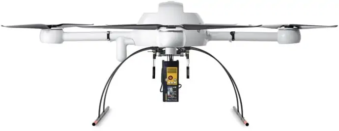
The mdTector1000 CH4 package features a Pergam gas sensor mounted and integrated with the Microdrones md4-1000 UAV (unmanned aerial vehicle). Users can see aerial shots in real time of what is being detected with the laser sensor. The sturdy carbon-fiber built UAV can easily navigate terrain that is too dangerous for traditional foot crews.

The mdTector1000 CH4 is a versatile package that can be used for:

  • natural gas line surveys
  • tank inspections
  • gas well testing
  • plant safety
  • landfill emission monitoring

“This is the drone package we’ve been eagerly developing, to provide current and new customers with the professional tools to get work done, all in one,” said Mike Hogan, Microdrones Sales Director for the Americas. “Providing new products to customers that expand our reach across the globe is what we aim to do, giving the end user everything they need at their fingertips to accurately and efficiently retrieve data, safer than ever before.”

Johan Wictor, Business Development Manager for Pergam Technical Services, added, “The platform was very stable, which is crucial for methane detection. Data acquisition was very good and the ability to incorporate waypoints is a great benefit. We’re very excited to work with Microdrones to help market this platform.”

Package benefits include:

  • avoids risk of traditional gas detection methods
  • broad range of detection from 1-50,000 ppm x m
  • lightweight and easy to transport
  • easy to deploy and operate

Microdrones has also bundled the mdCockpit Android App as part of the package, allowing users to maintain visualization in-flight. A special mdTector app allows users to visualize and present all post-flight data on one map.

Posted by Mike Ball Mike Ball is our resident technical editor here at Unmanned Systems Technology. Combining his passion for teaching, advanced engineering and all things unmanned, Mike keeps a watchful eye over everything related to the unmanned technical sector. With over 10 years’ experience in the unmanned field and a degree in engineering, Mike’s been heading up our technical team here for the last 8 years. Connect & Contact

Latest Articles

High-Energy Density Batteries for Drones & Robotic Vehicles

The SCIO Brick® platform offers industry-leading energy density in a compact and lightweight footprint, and can be scaled to meet high-voltage requirements

Jul 12, 2025
Most Read Articles on UST This Week

Here’s our round-up of the five most read articles on UnmannedSystemsTechnology.com this week

Jul 11, 2025
Vertiq Speed Firmware v0.1.1 Now Available with Bug Fixes

Vertiq has released firmware v0.1.1 to correct a parameter bug affecting telemetry and 3D mode settings on select G1 and G2 modules

Jul 11, 2025
The Role of ROVs in Unmanned Marine Operations

Oceanbotics has answered the most common questions about ROVs, covering how they work, where they're used, and key capabilities

Jul 11, 2025
LiveU File Transfer Speeds Up Drone Data Delivery for Critical Missions

LiveU’s File Transfer enables rapid transmission of large drone data files, reducing delays and supporting faster decision-making in public safety and infrastructure operations.

Jul 11, 2025
Exploring Differences Between M9PLUS & M9 GNSS Antennas

Discover the key upgrades in Maxtena’s new M9PLUS GNSS antenna, including improved performance, signal purity, and multipath mitigation over the original M9

Jul 11, 2025

Featured Content

USAF Uses Inertial Labs Drone Lidar for Tree Obstruction Survey

The US Air Force successfully used Inertial Labs drone Lidar and cloud software to quickly map tree obstructions at Joint Base Lewis-McChord (JBLM), improving airfield safety

Jul 11, 2025
New UAV to Combine Solar Hydrogen & Battery Power for Extended Flight

XSun and H3 Dynamics are developing the first UAV powered by solar, hydrogen, and batteries, aiming to deliver zero-emission, long-endurance unmanned flight

Jul 07, 2025
Enhancing Mangrove Restoration Through 3D Printed Drone Design

Explore how Inverto Earth, in collaboration with HP Additive, is using sustainable 3D printing and drone technology to drive large-scale mangrove restoration and protect vulnerable coastal ecosystems

Jul 03, 2025
Advancing Unmanned Systems Through Strategic Collaboration UST works with major OEMs to foster collaboration and increase engagement with SMEs, to accelerate innovation and drive unmanned systems capabilities forward.