3DR has announced that users of the Site Scan drone software platform for construction and engineering teams now have the ability to capture and use structurally-detailed thermal imagery on their projects. This is made possible through integration with the DJI M210 dual gimbal drone, equipped with the Zenmuse XT thermal camera and the Zenmuse X4S, making it easy to capture and combine thermal and RGB imagery.
The autonomous thermal mapping and modelling capability, using this dual-gimbal solution with the XT camera, is powered by FLIR Systems, a developer of thermal imaging solutions.
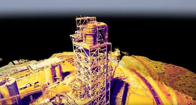
“Site Scan’s unique ability to generate structurally detailed thermal point clouds is a brand new capability for our customers across engineering, construction, and mining,” said Chris Anderson, CEO, 3DR. “Now, Site Scan users can easily inspect buildings, structures, and utilities, map solar arrays, monitor concrete curing, and much more. We’re excited to see how our customers put thermal imaging to work on their projects.”
Site Scan users plan and execute their flight with the M210 equipped with the XT and X4S, and the imagery from both cameras will automatically upload to the cloud and turn into thermal maps and models using Pix4D’s thermal processing capabilities.
As part of this release, Site Scan users can now also fly with the XT camera using a single gimbal on any of the the DJI M200 Series drones (M200, M210, M210 RTK). This makes it easier than ever to perform thermal inspections: Site Scan users can either fly single gimbal autonomous surveys, or fly manually and tap any part of their iPad screen to get a temperature reading of a specific area.
“As more enterprises deploy drones across their operations, many of them are realizing the impact thermal data can have on their sites,” said Jan Gasparic, Head of Enterprise Partnerships at DJI. “With the new thermal capabilities of 3DR’s Site Scan platform, these enterprises have a seamless and automated way to transition from a DJI M200 Series drone out in the field to meaningful analytics of thermal data in the office.”
“Thermal imaging has become a core tool for commercial drone operators to use on the job,” said Frank Pennisi, President of the Industrial Business Unit at FLIR. “The ability to use a drone to see heat and now map it with 3DR Site Scan will enable the industry to increase efficiency, reduce costs, and do more with thermal imaging.”