Oxford Technical Solutions has announced that its xOEM550 integrated inertial navigation system (INS) has been selected for incorporation into 3D Target’s Scanfly lightweight integrated LiDAR system. Scanfly has been designed for multiple platforms including unmanned aerial vehicles (UAVs), ground vehicles and pedestrians, and required an INS solution that would ensure robust, survey-grade georeferencing in all conditions while keeping size and weight to a minimum.
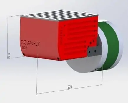
The Scanfly system is a complete LiDAR payload solution built around the popular Velodyne VLP-16 scanner. Although initially designed with UAV mapping in mind, it can be mounted on any vehicle, including cars/vans, boats, and even pedestrians in a backpack configuration.
In order to provide the required accuracies for commercial mapping applications on land and in air, the xOEM550 INS/GNSS from OxTS was chosen by the Scanfly development team after evaluating a range of available sensors. As a single OEM board set solution weighing 165 g, the xOEM550 met all performance and integration requirements.
The integrated RTK GNSS receivers provide absolute georeferencing accuracy down to the centimetre, while the dual antennas enable static initialisation – allowing UAV systems to initialise and start logging data before take-off. The dual receivers also enhance heading performance, reaching 0.1° accuracy that is stable even in low dynamics, limiting drift while hovering.
One aspect not often considered for UAV-based LiDAR mapping systems is performance when GNSS signals are blocked or disrupted. In most cases, UAVs are operated in open sky conditions with good GNSS visibility. However, a multi-platform solution that can also be used on ground vehicles and pedestrians is much more likely to encounter difficult GNSS environments. This can include urban canyons, bridges, tunnels, and vegetation canopies. UAV applications may also start encountering these environments as the market continues to grow and develop. In these conditions, the GNSS+IMU sensor fusion in the xOEM550 comes into play, and the gx/ix tight-coupling technology helps maintain accuracy and limit GNSS drift, even when fewer than 4 satellites are in view.
The Scanfly system offers a new LiDAR scanning solution for the ever expanding UAV market, as well as established mobile mapping markets and new ventures with pedestrian-based mapping. Further planned developments will add SLAM algorithms to aid indoor and underground surveying.
xOEM550 Key Features
- 2 cm RTK position
- 05° roll/pitch
- 1° dual antenna true heading
- gx/ix tight-coupling and PPK technology
- Software suite with post-processing included
Scanfly Key Features
- 16 channel, dual return laser
- 100 m range
- 360° HFOV
- UAV, ground vehicle, backpack configurations
- LiDAR + trajectory point cloud creation tool