


Pix4D, a pioneering developer of software tools that create professional-grade georeferenced maps and models from drone-captured imagery, has partnered with Unmanned Systems Technology (“UST”) to demonstrate their expertise in this field. The ‘Gold’ profile showcases how their mapping software is used in a wide variety of UAV (unmanned aerial vehicle)-driven industries, including surveying, construction, agriculture and real estate.
 The Pix4Dmapper Pro software package automatically converts images taken by drone, by manned aircraft or by hand and delivers high-precision, professional-grade georeferenced 2D maps and 3D models.
Key outputs include: 3D Point Cloud, Digital Surface and Terrain Models, Volume Calculations, Contour Lines, Orthomosaics, Thermal Maps and 3D Textured Mesh.
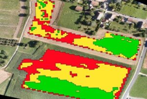 Pix4Dag is specialized drone mapping software that converts multispectral images into accurate reflectance and index maps, such as NDVI, and uses RGB images to generate high resolution orthomosaics. Pix4Dag allows users to easily integrate drone-based technology into precision agriculture and aerial crop analysis operations.
Key outputs include: Reflectance Maps, Index Maps, Orthomosaics, and Application Maps.
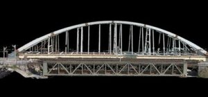
 Pix4Dbim empowers construction site developers to visualize, measure and verify as-built data using flexible image processing options either on desktop systems or in the cloud. Deliverables can be analyzed and shared via a cloud-based server and compared to BIM (Building Information Modelling) as-design or schedule drawings.
Key outputs include: Photorealistic 3D Models for Measurements, Cloud-Based Timeline, and BIM Comparison for As-Built vs As-Design.
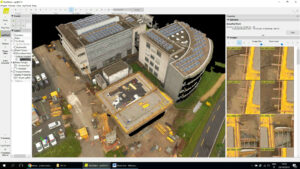
Pix4Dmodel processes drone-captured images automatically to create photorealistic 3D models, with the ability to export fly-through videos and full-textured-mesh models to showcase on the web and on social media. 3D models can be exported in a variety of file formats to upload on Sketchfab and other online 3D-visualization platforms.
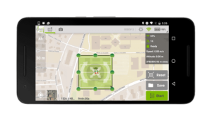 Pix4Dcapture is a free companion mobile app that allows drone pilots to create flight plans for capturing image data. Projects and missions can be planned in advance or in the field, and individual flight missions or entire projects can be recreated for efficient future use. Users can customize mission parameters, including altitude, image overlap, and more, or use mission templates tailored to creating an orthomosaic or 3D model. Post-flight, missions can be reviewed while still on site, before transferring the data to Pix4D desktop or cloud software for processing, analyzing and sharing.
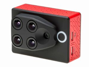 The Sequoia is a multispectral sensor designed for precision agriculture that captures discrete wavelengths of light, including Green, Red, Red-Edge and Near Infrared, to help better determine crop health by monitoring problem areas such as nutrient deficiencies and water stress, and to optimize pesticide input and crop yield.
Sequoia features a quad-band sensor and RGB camera for superior multispectral accuracy. A fully-integrated sunshine sensor captures and logs the current lighting conditions and automatically calibrates outputs of the camera so measurements are absolute. The unit can be easily integrated into a wide variety of fixed-wing and multi-rotor drones.
To find out more about Pix4D, please visit their profile page:
https://www.unmannedsystemstechnology.com/company/pix4d/


