AirMap has released a new app for iOS and Apple Watch, which allows drone operators to access low-altitude airspace advisories, create flights, file digital flight notices to over 80 airports, manage unmanned aircraft, and more. Building on the success of AirMap’s Digital Notice and Awareness System™ (D-NAS), the AirMap app brings to iOS devices a fully integrated airspace management solution for recreational and commercial drone operators.
Ben Marcus, CEO of AirMap and an airline transport rated pilot and flight instructor, said, “Everyone involved in aviation sees the promise and potential of unmanned aircraft. At AirMap, we believe the potential of this amazing technology cannot be reached unless we ensure that safety critical information keeps pace with innovation. We are focused on building the tools for unmanned aircraft to safely integrate into the national airspace system. This iOS app is one more tool in our ever growing ecosystem of safety solutions.”
Launched in March 2016 in collaboration with the American Association of Airport Executives (AAAE), D-NAS was created to allow operators of unmanned aerial systems (UAS) to provide airports with real-time digital information about the location of their flights. Airports access this information through the AirMap D-NAS dashboard, which provides a map view of flights in proximity to the airport and the option to contact the UAS operator directly. In addition to providing heightened awareness to airports, D-NAS makes it easy for UAS operators to comply with Section 336 of the FAA Modernization and Reform Act of 2012, which requires operators to provide notice of drone flights within a five-mile radius of the airport.
A UAS operator may send an encrypted digital flight notice to a secure dashboard at an airport’s operations center through a variety of interfaces, including AirMap’s iOS and Apple Watch apps, the AirMap website, various airport websites incorporating AirMap services, and soon the flying apps provided by leading drone manufacturers DJI, Yuneec, and 3DRobotics.
“The iOS app is the newest tool in our suite of technologies that allows people to communicate with our airspace management system,” said Greg McNeal, co-founder of AirMap. “The AirMap ecosystem includes software integrations into DJI, 3DR, and Yuneec. It includes over 80 airports in the United States, including major hubs like Los Angeles International, Houston Intercontinental, and Denver International, as well as Air Force bases.”
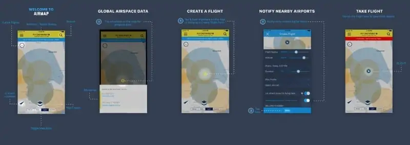
In the AirMap iOS app, UAS operators can view airspace data, including live temporary flight restrictions, toggle airspace information and advisory map overlays, create a pilot profile, manage UAS, create and manage present or future flights, file digital flight notifications, view public flights, search map by place or location, and more.
The AirMap iOS app is available for download in the App Store. Features and capabilities of the AirMap iOS app are available to manufacturers and app developers via the AirMap SDK.