 Velodyne LiDAR, a developer of LiDAR sensors and technologies, has announced that a wide variety of implementations of its compact 3D real-time sensors were showcased at the InterGEO 2015 trade show in Stuttgart, Germany.
While surveyors have traditionally mounted LiDAR scanners on tripods, these new technologies emphasise mobility, with lightweight scanners positioned on mobile platforms, gathering data while continuously moving through the environment and without stopping traffic or placing measuring crews in harm’s way. Mobile vehicles equipped with 3D LiDAR, video and GPS/IMU are already a common sight in major cities, soon to be joined by backpack-based mobile mapping for areas that are inaccessible to vehicles.
The following integrations of Velodyne’s LiDAR technology were demonstrated at InterGEO:
Backpack-based surveying – Velodyne’s compact VLP-16 LiDAR Puck – a lightweight 16-channel 3D, real-time scanner – was an integral part of systems on display by Microsoft and Leica Geosystems. Leica’s backpack, which received the prestigious InterGEO Wichmann Award during the show, utilized two of Velodyne’s LiDAR Pucks in order to obtain almost full 360° coverage in horizontal and vertical directions, with remarkable point cloud density.
Vehicle-based mapping – Leica also displayed its established Pegasus II vehicle-based mobile mapping solution, with the optional Velodyne HDL-32E 32-channel sensor on board. Topcon, another developer of vehicle-based mobile mapping solutions, showcased its IP-S3, which also deployed Velodyne’s HDL-32E, in combination with a camera and in-house navigational equipment.
Segway-driven mapping – Swedish company Satlab showcased a novel, real-time 3D integration of Velodyne’s compact VLP-16 on a Segway, complementing its vehicle-based mapping solution, also on display at InterGEO, built around the HDL-32E.
Marine implementations – In addition to displaying an HDL-32E-based mobile mapping solution under its Zenith brand, Dutch innovator Seabed combined Velodyne’s 16-channel LiDAR Puck with a multi-channel sonar scanner, enabling 3D measurements both above the water line and submerged below the water line.
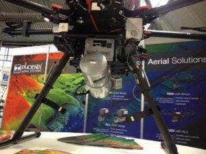
Airborne mapping – A number of system integrators at InterGEO offered airborne LiDAR solutions, among them UAV provider Phoenix Aerial Systems. Phoenix Aerial showcased its third generation AL3 platform using the HDL-32E with application examples ranging from power line inspection to oil & gas and in the mining sector. Phoenix’s Scout system utilized a lightweight VLP-16 for similarly demanding applications.
Forest management – Specializing in UAV-based LiDAR solutions used for forest management, LiForest showed their Li-Air capturing point clouds with Velodyne’s sensors, the HDL-32E and the VLP-16. The Li-Air solution analyzes the point clouds to isolate individual trees and establish databases that contain tree height, volume and density measurements.
“As InterGEO demonstrated conclusively, the power and versatility of our LiDAR sensors is unprecedented in the industry,” said Mike Jellen, Velodyne president. “Across a range of market segments and applications, our scanners are providing essential enabling technology. As our relationships with our integration partners continue to grow and deepen, we look forward to innovating in ways that enrich users and build markets.”